
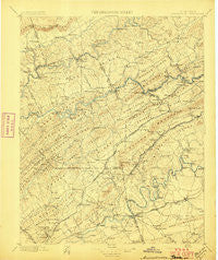
~ Maynardville TN topo map, 1:125000 scale, 30 X 30 Minute, Historical, 1897
Maynardville, Tennessee, USGS topographic map dated 1897.
Includes geographic coordinates (latitude and longitude). This topographic map is suitable for hiking, camping, and exploring, or framing it as a wall map.
Printed on-demand using high resolution imagery, on heavy weight and acid free paper, or alternatively on a variety of synthetic materials.
Topos available on paper, Waterproof, Poly, or Tyvek. Usually shipping rolled, unless combined with other folded maps in one order.
- Product Number: USGS-5339034
- Free digital map download (high-resolution, GeoPDF): Maynardville, Tennessee (file size: 8 MB)
- Map Size: please refer to the dimensions of the GeoPDF map above
- Weight (paper map): ca. 55 grams
- Map Type: POD USGS Topographic Map
- Map Series: HTMC
- Map Verison: Historical
- Cell ID: 66011
- Scan ID: 153522
- Survey Year: 1895
- Datum: Unstated
- Map Projection: Unstated
- Map published by United States Geological Survey
- Map Language: English
- Scanner Resolution: 600 dpi
- Map Cell Name: Maynardville
- Grid size: 30 X 30 Minute
- Date on map: 1897
- Map Scale: 1:125000
- Geographical region: Tennessee, United States
Neighboring Maps:
All neighboring USGS topo maps are available for sale online at a variety of scales.
Spatial coverage:
Topo map Maynardville, Tennessee, covers the geographical area associated the following places:
- Zacharytown - Loveland - Spring Place - Fieldview - Oakland - Alena (historical) - Sunset - Wooddale - Emory Estates - Alder - Fults Trailer Park - Carter - Minkton (historical) - Arminda - New Corinth - Hinds Creek Valley - Antioch - Halls - Yoakum Crossroad - Tazewell - Chilhowee Hills - Eastwood - Mill Spring - Deer Ridge Mobile Home Court - Kings Valley - Hodges - Agreeable (historical) - Pleasant Grove - Powells River (historical) - North Hills - Corinth - Hurricane Branch (historical) - Arlington - Williams Springs - Graveston - Head of Barren - Carr Branch - Powder Springs - Strawberry Plains - Buffalo Springs - Richland - Mayo (historical) - North Knoxville - Briarwood Estates - New Loyston - Highberry Trailer Park - Copper Ridge - Sandlick - Edmondson (historical) - Bayless (historical) - Oakman (historical) - Russell Mill - Acuff - Mascot - Wyricktown - Oak Grove - Clear Springs - Saddle Ridge - Hurst Mill - Dumplin - Goin - Condon - Pinhook - Clouds - Navehill - Rose Hill - Pleasant (historical) - Welch Crossroad - Greenwood Forest - Temple Acres - Pedigo - Sumter Hills - Loyston (historical) - Greenway - John Sevier - White Hollow - Sentertown - Paulette - Brookfield Acres - Inskip - Rule (historical) - Shipetown - Murphy Hills - Cedar Crest North - Dykes - Lost Creek (historical) - Long Hollow (historical) - Murphy Mill - Three Points - Melbourne - Liberty Hill - Whittle Springs - Mill Run - Clear Springs (historical) - Harbison Crossroads - Haynes (historical) - Buffat Heights - Ashby (historical) - Norwood - Thorn Grove
- Map Area ID: AREA36.536-84-83.5
- Northwest corner Lat/Long code: USGSNW36.5-84
- Northeast corner Lat/Long code: USGSNE36.5-83.5
- Southwest corner Lat/Long code: USGSSW36-84
- Southeast corner Lat/Long code: USGSSE36-83.5
- Northern map edge Latitude: 36.5
- Southern map edge Latitude: 36
- Western map edge Longitude: -84
- Eastern map edge Longitude: -83.5


