
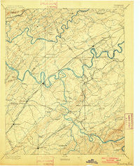
~ Loudon TN topo map, 1:125000 scale, 30 X 30 Minute, Historical, 1895, updated 1901
Loudon, Tennessee, USGS topographic map dated 1895.
Includes geographic coordinates (latitude and longitude). This topographic map is suitable for hiking, camping, and exploring, or framing it as a wall map.
Printed on-demand using high resolution imagery, on heavy weight and acid free paper, or alternatively on a variety of synthetic materials.
Topos available on paper, Waterproof, Poly, or Tyvek. Usually shipping rolled, unless combined with other folded maps in one order.
- Product Number: USGS-5339024
- Free digital map download (high-resolution, GeoPDF): Loudon, Tennessee (file size: 7 MB)
- Map Size: please refer to the dimensions of the GeoPDF map above
- Weight (paper map): ca. 55 grams
- Map Type: POD USGS Topographic Map
- Map Series: HTMC
- Map Verison: Historical
- Cell ID: 65939
- Scan ID: 153516
- Imprint Year: 1901
- Survey Year: 1891
- Datum: Unstated
- Map Projection: Unstated
- Map published by United States Geological Survey
- Map Language: English
- Scanner Resolution: 600 dpi
- Map Cell Name: Loudon
- Grid size: 30 X 30 Minute
- Date on map: 1895
- Map Scale: 1:125000
- Geographical region: Tennessee, United States
Neighboring Maps:
All neighboring USGS topo maps are available for sale online at a variety of scales.
Spatial coverage:
Topo map Loudon, Tennessee, covers the geographical area associated the following places:
- Greenback - Fox Fire - DeArmond - West Hills - Orchard Valley Estates - Aldenwood Park - Chilhowee - Kingston Hills - Blair - Woodchase - Karns Mobile Home Kort - Phillips - Oral - Allegheny Springs (historical) - Suburban Hills - Plum Creek - Chota (historical) - Village Green - Walker Subdivision - Old Sweetwater - Hidden Valley - Walnut Hill Estates - Garland - Christy Hill - Fagin - Cusick - King Arthur Court - Peninsular Estates - Meadowbrook - Fort Loudon Estates - Vonore - Bent Tree - Heather Heights - Blue Gem - Fairway Estates - Coulter Shoals - Middlebrook Acres - Bearden - Sweetwater - Edington (historical) - Wedgewood Hills - Craigmar (historical) - Ridgedale - Sharp Estates - Eagles Landing Mobile Home Park - Fox Den - Bell Spring - Deane Hill - Martel Estates East - Solway - Cedar Hills - Sherril Heights - Paint Rock Farm Lake Estates - Wood - Belmont West - Edgewater Estates - Ford - New Midway - Beaver Creek Estates - Macedonia - Tekoa - Greenwood Heights - Halfway Town (historical) - Volunteer Village - Coytee (historical) - Oak Grove Heights - Brick Mill - Highland Park - Sequoyah Estates - Vancouver (historical) - Byington - Greenwood - Mint - Northshore Woods - Cave Creek - Burton Mill - Woodland Acres - Brakebill (historical) - Sugar Grove - Riverbend Estates - Twin Springs - Bestview - Westborough - Scenic Point Estates - Hidden Hills - Eaton Forest - Mount Zion - Lovell Heights - Station West - Lawnville - Trails End - Chestnut Hills - Lakewood - Wood Creek West - Robinson Crossroads - Golden Meadows - Clover Hill Estates - Cactus Cove - Concords Woods - Stonebrook
- Map Area ID: AREA3635.5-84.5-84
- Northwest corner Lat/Long code: USGSNW36-84.5
- Northeast corner Lat/Long code: USGSNE36-84
- Southwest corner Lat/Long code: USGSSW35.5-84.5
- Southeast corner Lat/Long code: USGSSE35.5-84
- Northern map edge Latitude: 36
- Southern map edge Latitude: 35.5
- Western map edge Longitude: -84.5
- Eastern map edge Longitude: -84


