
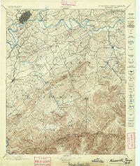
~ Knoxville TN topo map, 1:125000 scale, 30 X 30 Minute, Historical, 1895
Knoxville, Tennessee, USGS topographic map dated 1895.
Includes geographic coordinates (latitude and longitude). This topographic map is suitable for hiking, camping, and exploring, or framing it as a wall map.
Printed on-demand using high resolution imagery, on heavy weight and acid free paper, or alternatively on a variety of synthetic materials.
Topos available on paper, Waterproof, Poly, or Tyvek. Usually shipping rolled, unless combined with other folded maps in one order.
- Product Number: USGS-5339008
- Free digital map download (high-resolution, GeoPDF): Knoxville, Tennessee (file size: 10 MB)
- Map Size: please refer to the dimensions of the GeoPDF map above
- Weight (paper map): ca. 55 grams
- Map Type: POD USGS Topographic Map
- Map Series: HTMC
- Map Verison: Historical
- Cell ID: 320661
- Scan ID: 153455
- Visual Version Number: 1
- Survey Year: 1890
- Datum: Unstated
- Map Projection: Unstated
- Map published by United States Geological Survey
- Map Language: English
- Scanner Resolution: 600 dpi
- Map Cell Name: Knoxville
- Grid size: 30 X 30 Minute
- Date on map: 1895
- Map Scale: 1:125000
- Geographical region: Tennessee, United States
Neighboring Maps:
All neighboring USGS topo maps are available for sale online at a variety of scales.
Spatial coverage:
Topo map Knoxville, Tennessee, covers the geographical area associated the following places:
- Alder Branch - Sevierville - Moshina Heights - West Haven - Bittle Heights - Johnson Road - Plainfield - Mimosa Estates - Oak View - Happy Valley - Farrport - Lonsdale - Pigeon Forge - Bonny Kate - Union Valley - Elajay (historical) - Rockford - Chilhowee View - Henderson Springs - Singleton - Townsend - Southbrook - Mountain Trace - Millican Grove - Crossfield - Williamsburg - Alcoa - Oldfield Addition - Catlettsburg - Tuckaleechee - Eggers Addition - Wimbledon - Cherokee Park - Lakeview Estates - Dumplin Mill - Oaklawn Addition - Old Chilhowee - Fairfield - Boyds Creek - Stony Point - Crenshaw - Middlebrook Heights - Wear Valley - Burlington - Arrowhead - Lawson Crossroad - College Park Estates - Greystone Heights - Highland Acres - Newell Station - Kodak - Riverdale - Middle Creek - Bayview - Wildwood - Riverbend - Prospect - Timberlake - Topside - Powder Springs (historical) - Shooks - Holston Hills - Lyons View - Harth Addition - Valley Grove - West View - Watertown - Mooreland Heights - Coster Yards - New Era - Grandview - Gatlinburg - McMahan - Eagleton Village - Bethel - Beech Springs - Reagantown - Beechwood - Cherokee Hills - Rivertrace - Peters Mill - Windsor Park - Peppermint Hills - Woodfield Park - Hillsdale - Union Grove - Seven Islands - Hicks Crossing - Seaton - Bassel Addition - Marbledale - Asbury Estates - Creekwood - Asbury - Midway - Eastover - Sequoyah Hills - West Maryville - Lonas Addition - Mount Olive
- Map Area ID: AREA3635.5-84-83.5
- Northwest corner Lat/Long code: USGSNW36-84
- Northeast corner Lat/Long code: USGSNE36-83.5
- Southwest corner Lat/Long code: USGSSW35.5-84
- Southeast corner Lat/Long code: USGSSE35.5-83.5
- Northern map edge Latitude: 36
- Southern map edge Latitude: 35.5
- Western map edge Longitude: -84
- Eastern map edge Longitude: -83.5


