
~ Knoxville TN topo map, 1:125000 scale, 30 X 30 Minute, Historical, 1892
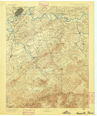
Knoxville, Tennessee, USGS topographic map dated 1892.
Includes geographic coordinates (latitude and longitude). This topographic map is suitable for hiking, camping, and exploring, or framing it as a wall map.
Printed on-demand using high resolution imagery, on heavy weight and acid free paper, or alternatively on a variety of synthetic materials.
Topos available on paper, Waterproof, Poly, or Tyvek. Usually shipping rolled, unless combined with other folded maps in one order.
- Product Number: USGS-5339004
- Free digital map download (high-resolution, GeoPDF): Knoxville, Tennessee (file size: 9 MB)
- Map Size: please refer to the dimensions of the GeoPDF map above
- Weight (paper map): ca. 55 grams
- Map Type: POD USGS Topographic Map
- Map Series: HTMC
- Map Verison: Historical
- Cell ID: 320661
- Scan ID: 153453
- Survey Year: 1890
- Datum: Unstated
- Map Projection: Unstated
- Map published by United States Geological Survey
- Map Language: English
- Scanner Resolution: 600 dpi
- Map Cell Name: Knoxville
- Grid size: 30 X 30 Minute
- Date on map: 1892
- Map Scale: 1:125000
- Geographical region: Tennessee, United States
Neighboring Maps:
All neighboring USGS topo maps are available for sale online at a variety of scales.
Spatial coverage:
Topo map Knoxville, Tennessee, covers the geographical area associated the following places:
- Mountain View Addition - Burlington - Iris Acres - Kimberlin Heights - Catlettsburg - Huskey Valley - Millican Grove - Grandview - Pleasant Hill - Greystone Heights - Henderson Springs - Kinzel Springs - Meadowbrook - Duncan - Townsend - Glenmore Estates - Montvale Springs - Norton Creek Ranch - Crossfield - Oldfield Addition - High Bluff - Cold Springs - Waldens Creek - West Haven - Southbrook - Calderwood - Sevierville - Yettland Park - Walland - Valley Grove - West View - Little Cove - Forest Hill - Hendron - West Knoxville - Forks of the River - Pigeon Forge - Littlebrook - East Springbrook - Westminister Ridge - Happy Valley - Colonial Village - Alder Branch - South View Estates - Willard Addition - Bank (historical) - Union Valley - Deep Creek - Cusick - Briarcliff - Rivertrace - Bayview - Lonsdale - East Forest - Revilo (historical) - Oxford Hills - Doyle Springs - Hillsdale - Cove Creek Cascades - Peppermint Hills - Midway - Seven Islands - Pitner (historical) - Jackson Hills - South Hall - Dellwood - Dupont Springs - Ramsey - Ewing (historical) - Wildwood - Welwyn (historical) - Everett Heights - Alcoa - Shooks - Westfields - Belmont Addition - Springbrook - Sherwood Forest - Stony Point - McMahan - Knob Creek - Westwood Hills - Montvue - Kodak - McCookville - Mimosa Estates - Oaklawn Addition - Plainfield - Highland Acres - Henry Crossroads - Heritage Hills - Sixmile - Forest Hills - Benford Heights Addition - Bassel Addition - Wear Valley - West Maryville - French Broad (historical) - Plainfield addition - Marble City
- Map Area ID: AREA3635.5-84-83.5
- Northwest corner Lat/Long code: USGSNW36-84
- Northeast corner Lat/Long code: USGSNE36-83.5
- Southwest corner Lat/Long code: USGSSW35.5-84
- Southeast corner Lat/Long code: USGSSE35.5-83.5
- Northern map edge Latitude: 36
- Southern map edge Latitude: 35.5
- Western map edge Longitude: -84
- Eastern map edge Longitude: -83.5


