
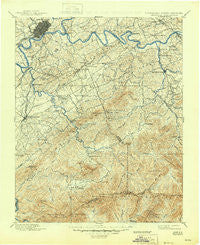
~ Knoxville TN topo map, 1:125000 scale, 30 X 30 Minute, Historical, 1901, updated 1945
Knoxville, Tennessee, USGS topographic map dated 1901.
Includes geographic coordinates (latitude and longitude). This topographic map is suitable for hiking, camping, and exploring, or framing it as a wall map.
Printed on-demand using high resolution imagery, on heavy weight and acid free paper, or alternatively on a variety of synthetic materials.
Topos available on paper, Waterproof, Poly, or Tyvek. Usually shipping rolled, unless combined with other folded maps in one order.
- Product Number: USGS-5339000
- Free digital map download (high-resolution, GeoPDF): Knoxville, Tennessee (file size: 9 MB)
- Map Size: please refer to the dimensions of the GeoPDF map above
- Weight (paper map): ca. 55 grams
- Map Type: POD USGS Topographic Map
- Map Series: HTMC
- Map Verison: Historical
- Cell ID: 320661
- Scan ID: 148003
- Imprint Year: 1945
- Survey Year: 1890
- Datum: Unstated
- Map Projection: Polyconic
- Map published by United States Geological Survey
- Map Language: English
- Scanner Resolution: 600 dpi
- Map Cell Name: Knoxville
- Grid size: 30 X 30 Minute
- Date on map: 1901
- Map Scale: 1:125000
- Geographical region: Tennessee, United States
Neighboring Maps:
All neighboring USGS topo maps are available for sale online at a variety of scales.
Spatial coverage:
Topo map Knoxville, Tennessee, covers the geographical area associated the following places:
- Asbury - Alcoa - Rocky Waters - Mount Zion - Little River - Plainfield - Deep Creek - Mountain View Addition - Lakemoor Hills - Forest Hills - Millican Grove - Highland Acres - Shooks - Wildwood - Underwood - Forks of the River - Tremont - Cusick - Johnson Road - Park Settlement - Pine Grove - Union Grove - Knoxville - Bayview - Sequoyah Hills - Seaton - Elkmont - Seymour Heights - Grandview Heights - Cave Mill - Peppermint Hills - Melrose - Wimbledon - Montvue - Kodak - Valley Grove - Bonny Kate - West Maryville - West Springbrook - Yettland Park - Sherwood Forest - Midway - Beech Springs - Summit Hills - Elajay (historical) - Oak View - Dumplin Mill - Revilo (historical) - Bethel - Burlington - Hillsdale - Cherokee Park - Watertown - Crenshaw - Tuckaleechee - Turnberry Vistas - Chandler - East Forest - Sevier Heights - New Hopewell - Vestal - Arrowhead - Chelsey Village - West View - Ramsey - Iris Acres - Holston Hills - Townsend - Fairview Heights - Buena Vista - Dupont Springs - Cherokee Hills - High Bluff - Harth Addition - Southbrook - Mimosa Estates - Sunshine - Timberlake - Sunset View - Deep Springs - Seymour - Henry Crossroads - Seven Islands - Lake Forest - Meadowood - Lonsdale - Hubbard - Singleton - Evergreen Pointe Mobile Home Park - Eastover - Blockhouse - Belle Meade - Meadowbrook - Middle Creek - Mule Hollow - Bittle Heights - Mountain Trace - Colonial Village - Mount Olive - Ford Addition
- Map Area ID: AREA3635.5-84-83.5
- Northwest corner Lat/Long code: USGSNW36-84
- Northeast corner Lat/Long code: USGSNE36-83.5
- Southwest corner Lat/Long code: USGSSW35.5-84
- Southeast corner Lat/Long code: USGSSE35.5-83.5
- Northern map edge Latitude: 36
- Southern map edge Latitude: 35.5
- Western map edge Longitude: -84
- Eastern map edge Longitude: -83.5


