
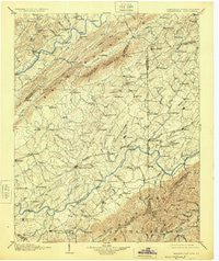
~ Greeneville TN topo map, 1:125000 scale, 30 X 30 Minute, Historical, 1904, updated 1925
Greeneville, Tennessee, USGS topographic map dated 1904.
Includes geographic coordinates (latitude and longitude). This topographic map is suitable for hiking, camping, and exploring, or framing it as a wall map.
Printed on-demand using high resolution imagery, on heavy weight and acid free paper, or alternatively on a variety of synthetic materials.
Topos available on paper, Waterproof, Poly, or Tyvek. Usually shipping rolled, unless combined with other folded maps in one order.
- Product Number: USGS-5338982
- Free digital map download (high-resolution, GeoPDF): Greeneville, Tennessee (file size: 8 MB)
- Map Size: please refer to the dimensions of the GeoPDF map above
- Weight (paper map): ca. 55 grams
- Map Type: POD USGS Topographic Map
- Map Series: HTMC
- Map Verison: Historical
- Cell ID: 65610
- Scan ID: 153444
- Imprint Year: 1925
- Survey Year: 1891
- Datum: NAD
- Map Projection: Polyconic
- Map published by United States Geological Survey
- Map Language: English
- Scanner Resolution: 600 dpi
- Map Cell Name: Greenville
- Grid size: 30 X 30 Minute
- Date on map: 1904
- Map Scale: 1:125000
- Geographical region: Tennessee, United States
Neighboring Maps:
All neighboring USGS topo maps are available for sale online at a variety of scales.
Spatial coverage:
Topo map Greeneville, Tennessee, covers the geographical area associated the following places:
- Pleasant Vale - Highland Hills - Fairview - Honeycutt - Holly Hills - Sullivan Gardens - Cherokee Estates - Taylor Acres - Maucks (historical) - Blossom - Lyons Store (historical) - Kepler - Cedar Lane - Ducktown - Kincheloe Mill - Chimneytop (historical) - Fairview - Gravel Hill - Home Field Terrace - Rader - Morelock (historical) - Big Creek - Green Acres - Mount Hope (historical) - Guntown - Washington College - Burem - Willis Subdivision - Dobson Subdivision - Deerfield - New Victory - Rocky Fork - Henard Mill - Poplar Grove - Harmony - DeRusk - Summey Subdivision - Craft Spring - Albany - Tanglewood Estates - Oak Hill - Chuckey - Double Springs - Twin Oaks - Broylesville - Bradburn Hill - Loganton (historical) - Honeys Hill - Gladstone - Derby (historical) - Van Hill - Mount Carmel - Coffee Ridge - Forest Hills - Surgoinsville - Ernestville - Milburnton - Babbs Mill - Windy Hills - Fall Branch - Heritage Hills - Midway - Keys Mill - Hickory Cove (historical) - Oak Hills - Limestone - Walkertown - Baileyton - Applewalk Park - Carmen - Conklin - Haws Crossroads - Mays Subdivision - Strahl - Nolichucky (historical) - Pine Grove - Jearoldstown - Leming Subdivision - Fairfield - Newmansville - Mosheim - Lone Star - Hickory Hills - Hartmantown - Chalk Level - Miller Flats - Sequoia Hills - Sunnyside - Water Fork Mill - Chestnut Ridge - Bolton Estates - Grandview - Stewart Hill - Greeneville - Upchurch - Goshen - Adams Mill - Cedar Creek - Glendale - Marvin
- Map Area ID: AREA36.536-83-82.5
- Northwest corner Lat/Long code: USGSNW36.5-83
- Northeast corner Lat/Long code: USGSNE36.5-82.5
- Southwest corner Lat/Long code: USGSSW36-83
- Southeast corner Lat/Long code: USGSSE36-82.5
- Northern map edge Latitude: 36.5
- Southern map edge Latitude: 36
- Western map edge Longitude: -83
- Eastern map edge Longitude: -82.5


