
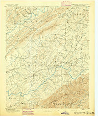
~ Greeneville TN topo map, 1:125000 scale, 30 X 30 Minute, Historical, 1892
Greeneville, Tennessee, USGS topographic map dated 1892.
Includes geographic coordinates (latitude and longitude). This topographic map is suitable for hiking, camping, and exploring, or framing it as a wall map.
Printed on-demand using high resolution imagery, on heavy weight and acid free paper, or alternatively on a variety of synthetic materials.
Topos available on paper, Waterproof, Poly, or Tyvek. Usually shipping rolled, unless combined with other folded maps in one order.
- Product Number: USGS-5338972
- Free digital map download (high-resolution, GeoPDF): Greeneville, Tennessee (file size: 7 MB)
- Map Size: please refer to the dimensions of the GeoPDF map above
- Weight (paper map): ca. 55 grams
- Map Type: POD USGS Topographic Map
- Map Series: HTMC
- Map Verison: Historical
- Cell ID: 65610
- Scan ID: 153439
- Survey Year: 1888
- Datum: Unstated
- Map Projection: Unstated
- Map published by United States Geological Survey
- Map Language: English
- Scanner Resolution: 600 dpi
- Map Cell Name: Greenville
- Grid size: 30 X 30 Minute
- Date on map: 1892
- Map Scale: 1:125000
- Geographical region: Tennessee, United States
Neighboring Maps:
All neighboring USGS topo maps are available for sale online at a variety of scales.
Spatial coverage:
Topo map Greeneville, Tennessee, covers the geographical area associated the following places:
- Big Creek - Kenneytown - Hacker (historical) - Fairfield - Hull Mill - Babbs Mill - Carmen - Rheatown - Horse Creek - Nolichucky (historical) - Twin Oaks - College Hills - Sunset Acres - New Victory - Honeycutt - Bolton Estates - Pine Grove - Wilhoit Subdivision - Castell Springs - Russell Crossroad - Harbour - Holland Mill - Chestnut Ridge - Highland Hills - Horse Creek - Sulphur Springs - Stewart Hill - McDonald Hill - Vogel (historical) - Limestone - Morelock (historical) - Home Field Terrace - Henard Mill - Whitesand - Van Hill - Westgate - Dobson Subdivision - Union Temple - Pleasant Vale - Craft Spring - Blue Ridge Estates - Kincheloe (historical) - Striggersville - Big Sandy - Upchurch - Hayesville - Wheelocktown (historical) - Grigsby - Oak Hill - Liberty - Mole - Longs Bend - Brotherton - Slaughter (historical) - Walkertown - Camp Creek - Sunnyside - Brittontown - Pilot Knob - Bowmantown - Greeneville - Deerfield - Cedar Hill - Spears (historical) - Rader - Woodlawn - Statemount (historical) - Cloverbottom (historical) - Timber Ridge - Petersburg - Lone Star - Parkland Acres - Stony Point - Gabtown - Flag Pond - Holly Hills - Oakland - Afton - Centersville - Tusculum Heights - Butcher (historical) - Loganton (historical) - Broylesville - Town Acres - Historic Hills - Eastview - Brownsboro (historical) - Washington College - Swanay (historical) - Phipps Bend - Cedar Hill - Lyons Store (historical) - Mays Subdivision - Couch (historical) - Easley Estates - Telford - Dykes Mill - Kincheloe Mill - Cherokee Estates - Mowls Mill
- Map Area ID: AREA36.536-83-82.5
- Northwest corner Lat/Long code: USGSNW36.5-83
- Northeast corner Lat/Long code: USGSNE36.5-82.5
- Southwest corner Lat/Long code: USGSSW36-83
- Southeast corner Lat/Long code: USGSSE36-82.5
- Northern map edge Latitude: 36.5
- Southern map edge Latitude: 36
- Western map edge Longitude: -83
- Eastern map edge Longitude: -82.5


