
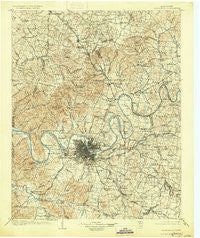
~ Greenbrier TN topo map, 1:125000 scale, 30 X 30 Minute, Historical, 1903, updated 1930
Greenbrier, Tennessee, USGS topographic map dated 1903.
Includes geographic coordinates (latitude and longitude). This topographic map is suitable for hiking, camping, and exploring, or framing it as a wall map.
Printed on-demand using high resolution imagery, on heavy weight and acid free paper, or alternatively on a variety of synthetic materials.
Topos available on paper, Waterproof, Poly, or Tyvek. Usually shipping rolled, unless combined with other folded maps in one order.
- Product Number: USGS-5338968
- Free digital map download (high-resolution, GeoPDF): Greenbrier, Tennessee (file size: 9 MB)
- Map Size: please refer to the dimensions of the GeoPDF map above
- Weight (paper map): ca. 55 grams
- Map Type: POD USGS Topographic Map
- Map Series: HTMC
- Map Verison: Historical
- Cell ID: 65604
- Scan ID: 153438
- Imprint Year: 1930
- Survey Year: 1901
- Datum: NAD
- Map Projection: Polyconic
- Map published by United States Geological Survey
- Map Language: English
- Scanner Resolution: 600 dpi
- Map Cell Name: Greenbrier
- Grid size: 30 X 30 Minute
- Date on map: 1903
- Map Scale: 1:125000
- Geographical region: Tennessee, United States
Neighboring Maps:
All neighboring USGS topo maps are available for sale online at a variety of scales.
Spatial coverage:
Topo map Greenbrier, Tennessee, covers the geographical area associated the following places:
- Scottish Highlands - Brentwood Park - Beverly Heights - Rest (historical) - Whispering Hills - West - Bakers - Whites Creek - Doziers (historical) - Little Creek - Oakvale - Avondale - Hillview - Myrtlewood Estates - Rural Hill - Scottsboro - East Point - Poplar Hills - Saundersville - Hygeia Springs - Mount Juliet - White House - Haysboro - Belle Rive - Lincoya Hills - Denny Hills - Buena Vista Estates - Oakwood Terrace - Williams Hills - Nashboro Village - Wilkerson (historical) - Donelson - Langford Cove - Forest Grove - Chestnut Grove - Benbar - Bethany Hills - Jefferson Pike - Curry (historical) - Grassland Estates - Metropolitan Government of Nashville-Davidson (balance) - Red Bud - Oglesby - Charlotte Park - Ivy Point - Greenbrier - Antioch - Driftwood Park - Kenilworth Estates - Rolling Acres - Germantown - Pointed Side Acres - Belle Rive Highlands - River Rest - Sarah Berry Annex - Brooklin - Meadowvale - Perry Park - Monticello - Wrencoe - Two Chestnut - Jackson Hollow - Pinnacle - Cloverhill - Indian Forest - Courtland - Greenlawn - Amqui - Mizell (historical) - Gilroy (historical) - Hermitage Hills - Bellshire - Devonshire Manor - Iroquois Meadows - Rockland - Williamsburg Estates - Lakeside Park - Murray Estates - Dog Town (historical) - Avondale - Jordonia - Point O'View - Goodlettsville - Madison - Hillview Estates - Oakmont - Deerwood - Baggettsville - Raintree Estates - Dalemere - Rosewood - Sunnyside Estates - Johnsons Crossroads - Brookview Estates - Hunters Ridge - Green Hill - Panorama Harbor - Hoffasville (historical) - Harbor View - Hite (historical)
- Map Area ID: AREA36.536-87-86.5
- Northwest corner Lat/Long code: USGSNW36.5-87
- Northeast corner Lat/Long code: USGSNE36.5-86.5
- Southwest corner Lat/Long code: USGSSW36-87
- Southeast corner Lat/Long code: USGSSE36-86.5
- Northern map edge Latitude: 36.5
- Southern map edge Latitude: 36
- Western map edge Longitude: -87
- Eastern map edge Longitude: -86.5


