
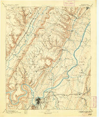
~ Chattanooga TN topo map, 1:125000 scale, 30 X 30 Minute, Historical, 1893, updated 1905
Chattanooga, Tennessee, USGS topographic map dated 1893.
Includes geographic coordinates (latitude and longitude). This topographic map is suitable for hiking, camping, and exploring, or framing it as a wall map.
Printed on-demand using high resolution imagery, on heavy weight and acid free paper, or alternatively on a variety of synthetic materials.
Topos available on paper, Waterproof, Poly, or Tyvek. Usually shipping rolled, unless combined with other folded maps in one order.
- Product Number: USGS-5338938
- Free digital map download (high-resolution, GeoPDF): Chattanooga, Tennessee (file size: 7 MB)
- Map Size: please refer to the dimensions of the GeoPDF map above
- Weight (paper map): ca. 55 grams
- Map Type: POD USGS Topographic Map
- Map Series: HTMC
- Map Verison: Historical
- Cell ID: 65175
- Scan ID: 153499
- Imprint Year: 1905
- Survey Year: 1886
- Datum: Unstated
- Map Projection: Unstated
- Map published by United States Geological Survey
- Map Language: English
- Scanner Resolution: 600 dpi
- Map Cell Name: Chattnooga
- Grid size: 30 X 30 Minute
- Date on map: 1893
- Map Scale: 1:125000
- Geographical region: Tennessee, United States
Neighboring Maps:
All neighboring USGS topo maps are available for sale online at a variety of scales.
Spatial coverage:
Topo map Chattanooga, Tennessee, covers the geographical area associated the following places:
- Vista Hills - Shannon Hills - Harbor Heights - Hampton Heights - J And B Mobile Home Park - Bella Vista Acres - Dallas Hollow - Turkeyfoot - Powells Crossroads - Mountain Shade Mobile Home Park - Laurel Creek - Oak Grove - Chattanooga - East Chattanooga - Pine Harbor Heights - Tiftonia - Fredonia - Northern Hills - Whispering Pines Mobile Home Park - Ryall Springs - Bartlebaugh - Ooltewah - Taylor Hill - Dale Acres - Savannah Bay - Richland Crest - Lakeshore Estates - Austin Farm - North Soddy - Shepherd - Spring Valley - Holiday Hills - Shawnee Park - Carriage Hill - Lone Oak - Lake Harbor Estates - Acres of Shade Mobile Home Park - Port Serena - Lakeshor Manor - Cloverdale Estates - Drake Forest - Elm Hill - Blue Ridge View - Blaney Forest - Mineral Park - Caramel Village - Colonial Village - Dallas Hills - Edgemont Forest - Easton Terrace - Mile Straight - Ridge Lake North - River Hills - Arcadia Shores - Dunlap - Yorktown Woods - Concord Heights - Skyline Park - Riverchase - Towne Hills - White Oak - Hidden Hills Estates - Tyner - Flat Top - Snow Hill - Harbour Woods - Holy Hills - Daus - Gold Point Estates - Dallas (historical) - Shore Acres - Highland Park - Holly Heights - Lake Village - Falling Water - Midvale - Stoneridge - Fairfax Heights - Mountain View - Alpine Heights - Green Acres - Harrison Point - Condra - Jeffery Acres - Farrington Forest - Fanetta Gardens - Ruby Falls - Rollingwood - Shady Acres - Signal Hills - Foxwood Heights - Lakesite - Apison - Quail Hollow - Galaxy Heights - Liberty - Timesville - Five Points - Forest Park - Shady Grove
- Map Area ID: AREA35.535-85.5-85
- Northwest corner Lat/Long code: USGSNW35.5-85.5
- Northeast corner Lat/Long code: USGSNE35.5-85
- Southwest corner Lat/Long code: USGSSW35-85.5
- Southeast corner Lat/Long code: USGSSE35-85
- Northern map edge Latitude: 35.5
- Southern map edge Latitude: 35
- Western map edge Longitude: -85.5
- Eastern map edge Longitude: -85


