
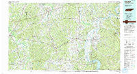
~ Selmer TN topo map, 1:100000 scale, 30 X 60 Minute, Historical, 1986, updated 1993
Selmer, Tennessee, USGS topographic map dated 1986.
Includes geographic coordinates (latitude and longitude). This topographic map is suitable for hiking, camping, and exploring, or framing it as a wall map.
Printed on-demand using high resolution imagery, on heavy weight and acid free paper, or alternatively on a variety of synthetic materials.
Topos available on paper, Waterproof, Poly, or Tyvek. Usually shipping rolled, unless combined with other folded maps in one order.
- Product Number: USGS-5338890
- Free digital map download (high-resolution, GeoPDF): Selmer, Tennessee (file size: 25 MB)
- Map Size: please refer to the dimensions of the GeoPDF map above
- Weight (paper map): ca. 55 grams
- Map Type: POD USGS Topographic Map
- Map Series: HTMC
- Map Verison: Historical
- Cell ID: 68345
- Scan ID: 148687
- Imprint Year: 1993
- Woodland Tint: Yes
- Visual Version Number: 2
- Aerial Photo Year: 1985
- Edit Year: 1986
- Datum: NAD27
- Map Projection: Universal Transverse Mercator
- Map published by Tennessee Valley Authority
- Map Language: English
- Scanner Resolution: 600 dpi
- Map Cell Name: Selmer
- Grid size: 30 X 60 Minute
- Date on map: 1986
- Map Scale: 1:100000
- Geographical region: Tennessee, United States
Neighboring Maps:
All neighboring USGS topo maps are available for sale online at a variety of scales.
Spatial coverage:
Topo map Selmer, Tennessee, covers the geographical area associated the following places:
- Shandy - Olivehill - Liberty - Rogers Springs - Holiday Hills - Nixon - Bethel Springs - Shady Grove - Piney Grove - Serles - Maddox - Tulu - Childers Hill - Thompson Crossroads - Lowryville - Thurman - Selmer - Hebron - Pollards Mill - Saltillo - Smiths Fork (historical) - Henderson - Walkertown - Lacy - Stantonville - Hamburg - Box Elder - Enville - Toone - Havana - Point Pleasant - West Hima - Unity - Hickory Flats - Center Point Lula - Gail (historical) - Olivet - Bethlehem - Hickory Corners - Pleasant Hill - Old Dunbar (historical) - Porters Creek - Caffey - Needmore - Pinson - Belle Meade - Swift - Bolivar - Gilchrist - Deanburg - Old Lawton - Beauty Hill - Roby - Gravel Hill - Pocahontas - Cabo - Lick Skillet - Falcon - Counce - Essary Springs - Mud Creek - Morris Chapel - Damon - Sanford Hill - Masseyville - Bethlehem - Pittsburg Landing - Caney Hollow - Haney - Stringtown - Rose Creek - Pleasant Grove - Walnut Grove - Bucktown - Cypress - Uptonville - White Sulphur (historical) - New Lawton - West Shiloh - Palestine - Gibbs (historical) - Oak Grove - Red Walnut - Liberty - Hinkle - Center Star - Piney Grove - New Hope - Milledgeville - Silerton - Mount Carmel - Good Hope - Bruton Branch - Walnut Grove (historical) - Jacks Creek - Centerview - Crump - Mount Vinson - Pine Top - Oak Grove
- Map Area ID: AREA35.535-89-88
- Northwest corner Lat/Long code: USGSNW35.5-89
- Northeast corner Lat/Long code: USGSNE35.5-88
- Southwest corner Lat/Long code: USGSSW35-89
- Southeast corner Lat/Long code: USGSSE35-88
- Northern map edge Latitude: 35.5
- Southern map edge Latitude: 35
- Western map edge Longitude: -89
- Eastern map edge Longitude: -88


