
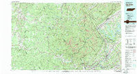
~ Oakridge TN topo map, 1:100000 scale, 30 X 60 Minute, Historical, 1979, updated 1980
Oakridge, Tennessee, USGS topographic map dated 1979.
Includes geographic coordinates (latitude and longitude). This topographic map is suitable for hiking, camping, and exploring, or framing it as a wall map.
Printed on-demand using high resolution imagery, on heavy weight and acid free paper, or alternatively on a variety of synthetic materials.
Topos available on paper, Waterproof, Poly, or Tyvek. Usually shipping rolled, unless combined with other folded maps in one order.
- Product Number: USGS-5338884
- Free digital map download (high-resolution, GeoPDF): Oakridge, Tennessee (file size: 29 MB)
- Map Size: please refer to the dimensions of the GeoPDF map above
- Weight (paper map): ca. 55 grams
- Map Type: POD USGS Topographic Map
- Map Series: HTMC
- Map Verison: Historical
- Cell ID: 68070
- Scan ID: 149184
- Imprint Year: 1980
- Woodland Tint: Yes
- Aerial Photo Year: 1976
- Edit Year: 1979
- Datum: NAD27
- Map Projection: Universal Transverse Mercator
- Map published by Tennessee Valley Authority
- Map Language: English
- Scanner Resolution: 600 dpi
- Map Cell Name: Oak Ridge
- Grid size: 30 X 60 Minute
- Date on map: 1979
- Map Scale: 1:100000
- Geographical region: Tennessee, United States
Neighboring Maps:
All neighboring USGS topo maps are available for sale online at a variety of scales.
Spatial coverage:
Topo map Oakridge, Tennessee, covers the geographical area associated the following places:
- Coal Hill - New River - Deep Springs - Valley View - Poplar - Briceville - Panther (historical) - Obed Junction - Davis Chapel - Marlow - New Haven - Lone Mountain - Cold Springs (historical) - Westwood Estates - Disney - Bethel - Powell - Mount Helen - Habersham - Pilot Mountain - Medford - Montgomery - Catoosa - Hunter - Edgemoor - Cumberland Grove - Newtown - Offutt - Frost - South Clinton - Jackson Square - Hatmaker (historical) - Emory Heights - Stephens - Pioneer - Oak Ridge - Glenmary - Valley View Heights - Fairview (historical) - Fraterville - Annadel - Speck - Dean - Jamestown - Jacksboro - Deermont - Sherwood Estates - White Oak - Rugby - Three Forks - Seeber Flats - Pine Crest - Moores Camp - Dossett - Spring Hill - Bucklick - Berkshire Forest - Coalfield - Cumberland View Mobile Home Park - Blowing Springs - Kalida - Oliver Springs - Midway - Lavender - Fordtown - Catoosa Country - Charleys Branch - Agee (historical) - Shea - Straight Fork - Clinch View - Mahan Village - Brewstertown - Mill Creek (historical) - Oak Hill - Robbins - Peewee - Khotan - Shadow Wood - Oneida - Terry Creek - Slate Springs - Gooseneck - Toomy - Boy (historical) - Banner Springs - Cotula - Union - Forest Hill (historical) - Broad Acres - Cove Lake Estates - Linger Lake - Liberty - Allardt - Boiling (historical) - Sunbright - Wiltshire - Adkins Mill - Sites Mobile Home Park - Glades
- Map Area ID: AREA36.536-85-84
- Northwest corner Lat/Long code: USGSNW36.5-85
- Northeast corner Lat/Long code: USGSNE36.5-84
- Southwest corner Lat/Long code: USGSSW36-85
- Southeast corner Lat/Long code: USGSSE36-84
- Northern map edge Latitude: 36.5
- Southern map edge Latitude: 36
- Western map edge Longitude: -85
- Eastern map edge Longitude: -84


