
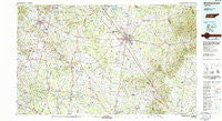
~ Murfreesboro TN topo map, 1:100000 scale, 30 X 60 Minute, Historical, 1985, updated 1986
Murfreesboro, Tennessee, USGS topographic map dated 1985.
Includes geographic coordinates (latitude and longitude). This topographic map is suitable for hiking, camping, and exploring, or framing it as a wall map.
Printed on-demand using high resolution imagery, on heavy weight and acid free paper, or alternatively on a variety of synthetic materials.
Topos available on paper, Waterproof, Poly, or Tyvek. Usually shipping rolled, unless combined with other folded maps in one order.
- Product Number: USGS-5338880
- Free digital map download (high-resolution, GeoPDF): Murfreesboro, Tennessee (file size: 24 MB)
- Map Size: please refer to the dimensions of the GeoPDF map above
- Weight (paper map): ca. 55 grams
- Map Type: POD USGS Topographic Map
- Map Series: HTMC
- Map Verison: Historical
- Cell ID: 68018
- Scan ID: 148601
- Imprint Year: 1986
- Woodland Tint: Yes
- Aerial Photo Year: 1981
- Edit Year: 1985
- Datum: NAD27
- Map Projection: Universal Transverse Mercator
- Map published by United States Geological Survey
- Map published by Tennessee Valley Authority
- Map Language: English
- Scanner Resolution: 600 dpi
- Map Cell Name: Murfreesboro
- Grid size: 30 X 60 Minute
- Date on map: 1985
- Map Scale: 1:100000
- Geographical region: Tennessee, United States
Neighboring Maps:
All neighboring USGS topo maps are available for sale online at a variety of scales.
Spatial coverage:
Topo map Murfreesboro, Tennessee, covers the geographical area associated the following places:
- Landings - Manson Manor - Park Manor - Rocky Point (historical) - Iconium - Stone Ridge - Cadet - Creekwood - Bell Buckle - Pleasant View - Beasley Road - Franklin - Carman (historical) - Meadow Lane - Berea (historical) - Bethesda - Walter Hill Estates - Concord Country Estates - Jones Chapel (historical) - Eldorado Acres - Loafers Corner - Valleyview - Battleground Estates - Oak Hill - Bradyville - Jackson Ridge - Kittrell Heights - Douglas - Reidhurst - River Shores - Almaville - Lively - Farmington - Brenthaven East - Jimtown (historical) - Brownview Acres - Brentwood Pointe - Riggs Crossroads - Montpier Farms - Bethel - Prosperity - Cherry Hill Estates - Canebrake - Triune - Sowell Ford - Pottsville - Mount Olivet (historical) - Joywood - Sheybogan - Hunting Creek Farms - Holly (historical) - Brysonville - Vannatta - Anchor Mill - Green Valley Estates - Beechwood - Jernigan (historical) - Circle J Park - Joyceland - Emery Estates - Compton - Shadowbrook - Glaze - Leanna - Satterfield (historical) - Walnut Grove - Fieldcrest - Juniper Acres - Poplins Crossroads - Glendale - Oregon (historical) - Lynnwood Downs - Green Acres - Readyville - Wilhoite Mills - Two Hills - Red Hill - Foxboro Estates - Cainsville - Quail Ridge - Hooker Hills - Deason - Jordan Acres - Williamsburg - Hopewell (historical) - Baucom - Sunny Slope - Stonebrook - Brenthaven North - Cherry Lane Acres - Berlin - Creekmont - Allisona - Curlee - Twin Springs Estates - Lascassas - Mooretown - Old Millersburg (historical) - Fudgearound - Bluefield
- Map Area ID: AREA3635.5-87-86
- Northwest corner Lat/Long code: USGSNW36-87
- Northeast corner Lat/Long code: USGSNE36-86
- Southwest corner Lat/Long code: USGSSW35.5-87
- Southeast corner Lat/Long code: USGSSE35.5-86
- Northern map edge Latitude: 36
- Southern map edge Latitude: 35.5
- Western map edge Longitude: -87
- Eastern map edge Longitude: -86


