
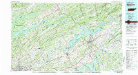
~ Morristown TN topo map, 1:100000 scale, 30 X 60 Minute, Historical, 1981, updated 1981
Morristown, Tennessee, USGS topographic map dated 1981.
Includes geographic coordinates (latitude and longitude). This topographic map is suitable for hiking, camping, and exploring, or framing it as a wall map.
Printed on-demand using high resolution imagery, on heavy weight and acid free paper, or alternatively on a variety of synthetic materials.
Topos available on paper, Waterproof, Poly, or Tyvek. Usually shipping rolled, unless combined with other folded maps in one order.
- Product Number: USGS-5338878
- Free digital map download (high-resolution, GeoPDF): Morristown, Tennessee (file size: 26 MB)
- Map Size: please refer to the dimensions of the GeoPDF map above
- Weight (paper map): ca. 55 grams
- Map Type: POD USGS Topographic Map
- Map Series: HTMC
- Map Verison: Historical
- Cell ID: 67990
- Scan ID: 150120
- Imprint Year: 1981
- Woodland Tint: Yes
- Aerial Photo Year: 1977
- Edit Year: 1981
- Datum: NAD27
- Map Projection: Universal Transverse Mercator
- Map published by Tennessee Valley Authority
- Map Language: English
- Scanner Resolution: 600 dpi
- Map Cell Name: Morristown
- Grid size: 30 X 60 Minute
- Date on map: 1981
- Map Scale: 1:100000
- Geographical region: Tennessee, United States
Neighboring Maps:
All neighboring USGS topo maps are available for sale online at a variety of scales.
Spatial coverage:
Topo map Morristown, Tennessee, covers the geographical area associated the following places:
- Cedar Hills - Laconte View Mobile Home Park - Cedar Grove - East Village - Ambro (historical) - White Pine - Beacon Hills - Chittum - Hickory - Holttown - Sunset - Buell Acres - Lilac (historical) - Mountain View - May Acres - Thula - Arminda - Liberty Heights - Maples (historical) - Westview - White Pine Mobile Home Park - Loo (historical) - Needmore - Luttrell - Witt - Turley Mills (historical) - Bayless (historical) - Keister - Bird Hill - Clear Springs (historical) - Thorn Hill - Lockmere Estates - Pineville - Lampkin Acres - Scoot Mill - Sugar Forks - Shipetown - Crockett Ridge - Hunnicutt Mill - Bald Point - Point Seven - McMillan - Woodburn (historical) - Clear Springs - Ridenour - Austins Mill - New Market - Norwood - Perrin Hollow - Lakeview - Pleasantview Acres - Big Barren - White Horn - Tampico - Clinch River (historical) - Northbrook - Bybee - Highberry Trailer Park - Hinds Creek Valley - Prima Estates - Chestnut Grove - Dry Gap - Sumter Hills - Jackson Heights - Dumplin - Still Brook - Lynndale - Lily Grove - Halls Crossroads - Sequooyah Estates - Trentville - Dante - Oak Grove - Patterson Hills - Big Creek - Dogwood Hills - Springvale - Wilderness Shores - Leadvale - Friends Station - Paradise Pointe - Three Points - Mill Run - Oakland - Blaine - Mapleview Acres - Wyricktown - Susong - Fernwood Heights - Jobe (historical) - Hales Crossroads - Dogwood Mobile Home Park - Howard Quarter - Union Heights - Wilson Gap - Alder Springs - Rankin - Little Barren - Pleasant view - Freeway
- Map Area ID: AREA36.536-84-83
- Northwest corner Lat/Long code: USGSNW36.5-84
- Northeast corner Lat/Long code: USGSNE36.5-83
- Southwest corner Lat/Long code: USGSSW36-84
- Southeast corner Lat/Long code: USGSSE36-83
- Northern map edge Latitude: 36.5
- Southern map edge Latitude: 36
- Western map edge Longitude: -84
- Eastern map edge Longitude: -83


