
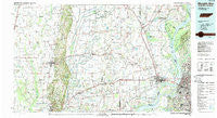
~ Memphis West TN topo map, 1:100000 scale, 30 X 60 Minute, Historical, 1986, updated 1989
Memphis West, Tennessee, USGS topographic map dated 1986.
Includes geographic coordinates (latitude and longitude). This topographic map is suitable for hiking, camping, and exploring, or framing it as a wall map.
Printed on-demand using high resolution imagery, on heavy weight and acid free paper, or alternatively on a variety of synthetic materials.
Topos available on paper, Waterproof, Poly, or Tyvek. Usually shipping rolled, unless combined with other folded maps in one order.
- Product Number: USGS-5338872
- Free digital map download (high-resolution, GeoPDF): Memphis West, Tennessee (file size: 22 MB)
- Map Size: please refer to the dimensions of the GeoPDF map above
- Weight (paper map): ca. 55 grams
- Map Type: POD USGS Topographic Map
- Map Series: HTMC
- Map Verison: Historical
- Cell ID: 67939
- Scan ID: 148578
- Imprint Year: 1989
- Woodland Tint: Yes
- Aerial Photo Year: 1981
- Edit Year: 1986
- Datum: NAD27
- Map Projection: Universal Transverse Mercator
- Map published by United States Geological Survey
- Map Language: English
- Scanner Resolution: 600 dpi
- Map Cell Name: Memphis West
- Grid size: 30 X 60 Minute
- Date on map: 1986
- Map Scale: 1:100000
- Geographical region: Tennessee, United States
Neighboring Maps:
All neighboring USGS topo maps are available for sale online at a variety of scales.
Spatial coverage:
Topo map Memphis West, Tennessee, covers the geographical area associated the following places:
- Crow Creek - Persey - Deans Island - Memphis - New South Memphis - Ebony - Engledale (historical) - Almont (historical) - Fisher - Coldwater - Foote Homes - Welford (historical) - Frayser - Julius - Midway - Yarbo Place - Rose Place - Duvall - Stewart - Kate - Wildcat (historical) - Macedonia - Simsboro - Kinton - Whitmore - Caldwell - Hamlin - Beasley - Goodman - Wynne - Briark - Shadowlawn - Clarks Corner - Dimple - Shell Lake - Colt - Hawkins - Levesque - Fitzgerald Crossing - Booker - Heafer - Pleasant Hill - Shiloh - Dunn (historical) - Annesdale-Snowden - Wittsburg - McDonald - Democrat - White Chapel - L'Anguille - Quarles - Fortune - Millers - New Home - Ellis Chapel - Monterey - Newcastle - Whitehaven - Arthur (historical) - Pecan Point - Shearerville - Merck (historical) - Norvell - Mound City - Cunningham Corner - Lauderdale Courts - East Junction - Boat Run - Topaz - Scanlan (historical) - Bailes (historical) - Slonikers Mill - Cottonwood Corner - Locke - Mounds - Whitehall - Wildwood - Stonewall Place - Darwin - Lansing - Hunt Village - Mount Olive - Crittenden - Colton Crossing - Vincent - Bunker Hill - Telico (historical) - Jennette - Brice - Rosine - Heth - Black Cat - Budsmith (historical) - Rosemary Lane - Saint Thomas - Earle - Lehi - Black Oak - Bauxippi (historical) - Greasy Corner
- Map Area ID: AREA35.535-91-90
- Northwest corner Lat/Long code: USGSNW35.5-91
- Northeast corner Lat/Long code: USGSNE35.5-90
- Southwest corner Lat/Long code: USGSSW35-91
- Southeast corner Lat/Long code: USGSSE35-90
- Northern map edge Latitude: 35.5
- Southern map edge Latitude: 35
- Western map edge Longitude: -91
- Eastern map edge Longitude: -90


