
~ Memphis East TN topo map, 1:100000 scale, 30 X 60 Minute, Historical, 1986, updated 1986
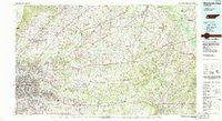
Memphis East, Tennessee, USGS topographic map dated 1986.
Includes geographic coordinates (latitude and longitude). This topographic map is suitable for hiking, camping, and exploring, or framing it as a wall map.
Printed on-demand using high resolution imagery, on heavy weight and acid free paper, or alternatively on a variety of synthetic materials.
Topos available on paper, Waterproof, Poly, or Tyvek. Usually shipping rolled, unless combined with other folded maps in one order.
- Product Number: USGS-5338868
- Free digital map download (high-resolution, GeoPDF): Memphis East, Tennessee (file size: 26 MB)
- Map Size: please refer to the dimensions of the GeoPDF map above
- Weight (paper map): ca. 55 grams
- Map Type: POD USGS Topographic Map
- Map Series: HTMC
- Map Verison: Historical
- Cell ID: 76827
- Scan ID: 148576
- Imprint Year: 1986
- Woodland Tint: Yes
- Visual Version Number: 2
- Aerial Photo Year: 1981
- Edit Year: 1986
- Datum: NAD27
- Map Projection: Universal Transverse Mercator
- Map published by Tennessee Valley Authority
- Map Language: English
- Scanner Resolution: 600 dpi
- Map Cell Name: Memphis East
- Grid size: 30 X 60 Minute
- Date on map: 1986
- Map Scale: 1:100000
- Geographical region: Tennessee, United States
Neighboring Maps:
All neighboring USGS topo maps are available for sale online at a variety of scales.
Spatial coverage:
Topo map Memphis East, Tennessee, covers the geographical area associated the following places:
- Griffen - Meux Corner - Raleigh - River Oaks - Capleville - Center Point - Forty Five - Hatchie - Overton - Mount Carmel - Somerville - Egypt - Van Buren - Yum Yum - Cedar Chapel - Hopewell - Drummonds - Cedar Grove (historical) - Rosemark - Grand Junction - Atoka - Irene (historical) - Morton Hill - Fredonia - Fayette Corners - Williston - Ko Ko - Barretville - Pattersonville - Hollywood - Normal - Birds Bower - Lakeland - Towering Heights - Ebenezer - Tipton - Mercer - Spring Hill - Germantown - Parkway Village - Zu Zu - Greenlawn - White Station - Fisherville - Wilkinsville - Dixonville - Bolton - Forest Hill - Saulsbury - Bartlett - Madge - Keeling - Quito - Spring Lake - Egypt - Sloanville - Longtown - Piperton - Bush Grove - Gallaway - Gildfield - Miller - Salem - Center Point (historical) - Clopton - New Bethel - Hickory Valley - Elba - Saint John - Bleak (historical) - Lenow - Newcastle - Ina (historical) - West Union - Millington - Sturdivant Crossing - Cloverport - Mason - Wells - Asbury - Mount Moriah - Brunswick - Canadaville - Aulon - Clay (historical) - Hedgemoor - Liberty Hill - Morningside Park - Woodstock - Belmont - Feathers Chapel - Munford - Sugar Hill - Bailey - Kerrville - Pea Point (historical) - Brookfield - Shelby Farms - Laconia - Lenox
- Map Area ID: AREA35.535-90-89
- Northwest corner Lat/Long code: USGSNW35.5-90
- Northeast corner Lat/Long code: USGSNE35.5-89
- Southwest corner Lat/Long code: USGSSW35-90
- Southeast corner Lat/Long code: USGSSE35-89
- Northern map edge Latitude: 35.5
- Southern map edge Latitude: 35
- Western map edge Longitude: -90
- Eastern map edge Longitude: -89


