
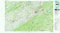
~ Johnson City TN topo map, 1:100000 scale, 30 X 60 Minute, Historical, 1980, updated 1981
Johnson City, Tennessee, USGS topographic map dated 1980.
Includes geographic coordinates (latitude and longitude). This topographic map is suitable for hiking, camping, and exploring, or framing it as a wall map.
Printed on-demand using high resolution imagery, on heavy weight and acid free paper, or alternatively on a variety of synthetic materials.
Topos available on paper, Waterproof, Poly, or Tyvek. Usually shipping rolled, unless combined with other folded maps in one order.
- Product Number: USGS-5338850
- Free digital map download (high-resolution, GeoPDF): Johnson City, Tennessee (file size: 27 MB)
- Map Size: please refer to the dimensions of the GeoPDF map above
- Weight (paper map): ca. 55 grams
- Map Type: POD USGS Topographic Map
- Map Series: HTMC
- Map Verison: Historical
- Cell ID: 67737
- Scan ID: 148000
- Imprint Year: 1981
- Woodland Tint: Yes
- Aerial Photo Year: 1976
- Edit Year: 1980
- Datum: NAD27
- Map Projection: Universal Transverse Mercator
- Map published by Tennessee Valley Authority
- Map Language: English
- Scanner Resolution: 600 dpi
- Map Cell Name: Johnson City
- Grid size: 30 X 60 Minute
- Date on map: 1980
- Map Scale: 1:100000
- Geographical region: Tennessee, United States
Neighboring Maps:
All neighboring USGS topo maps are available for sale online at a variety of scales.
Spatial coverage:
Topo map Johnson City, Tennessee, covers the geographical area associated the following places:
- Mount Pleasant - Applewalk Park - Tamarack - Brotherton - Watauga Flats - Fordville (historical) - Rayon Terrace - Holly Hills - Deerfield - Grandview - Austin Village - Austin Springs - Hulan Hollow - Colony Park - Wilbur - Watauga Point - Ernestville - Sequoia Hills - Hartmantown - Englewood - Buffalo View - Pine Timbers - Charity Hill - Housley - Underwood Springs (historical) - Watauga Valley - Miller - Brookmead - Woodstone - Matuta (historical) - Mount Carmel - Riovista - Sunset Acres - Camp Wildwood - Valley Park - Childress - Tamassee - Sequoyah Heights - Ducktown - Big Spring - Carnegie - Fairview - Plymouth Park - Walnut Grove - Unicoi - Lone Star - Morelock (historical) - Mole - Hawk - Swanay (historical) - Couch (historical) - Glen Ayre - Pactolus - Summersville - Stoney Brook - Wahoo (historical) - Little Milligan - Lake Crest - Union Temple - Shadtown - Pierce - Stacy - Westover - Gravel Hill - Boring - Little Chucky (historical) - Wildwood - Love Station - Fall Branch - Sumpter (historical) - Town Acres - Buckingham Heights - Mitchell Springs - Barnetts - Cardens Bluff (historical) - Keenburg - Foxxborough - Sunnyside - Plumtree - College View - Midway - Zion Hill - Ephraim Place - Cooktown - Philadelphia - Water Fork Mill - Heaton Creek - Vogel (historical) - Lovelace - Bowmantown - Relief - Conkintown - Roan Mountain - Embreeville - Mill Brook - Stowe Acres - Colonial Acres - Reston Court - Ramseytown - Meadowview
- Map Area ID: AREA36.536-83-82
- Northwest corner Lat/Long code: USGSNW36.5-83
- Northeast corner Lat/Long code: USGSNE36.5-82
- Southwest corner Lat/Long code: USGSSW36-83
- Southeast corner Lat/Long code: USGSSE36-82
- Northern map edge Latitude: 36.5
- Southern map edge Latitude: 36
- Western map edge Longitude: -83
- Eastern map edge Longitude: -82


