
~ Hohenwald TN topo map, 1:100000 scale, 30 X 60 Minute, Historical, 1986, updated 1993
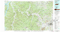
Hohenwald, Tennessee, USGS topographic map dated 1986.
Includes geographic coordinates (latitude and longitude). This topographic map is suitable for hiking, camping, and exploring, or framing it as a wall map.
Printed on-demand using high resolution imagery, on heavy weight and acid free paper, or alternatively on a variety of synthetic materials.
Topos available on paper, Waterproof, Poly, or Tyvek. Usually shipping rolled, unless combined with other folded maps in one order.
- Product Number: USGS-5338848
- Free digital map download (high-resolution, GeoPDF): Hohenwald, Tennessee (file size: 30 MB)
- Map Size: please refer to the dimensions of the GeoPDF map above
- Weight (paper map): ca. 55 grams
- Map Type: POD USGS Topographic Map
- Map Series: HTMC
- Map Verison: Historical
- Cell ID: 67673
- Scan ID: 143964
- Imprint Year: 1993
- Woodland Tint: Yes
- Visual Version Number: 2
- Aerial Photo Year: 1981
- Edit Year: 1986
- Datum: NAD27
- Map Projection: Universal Transverse Mercator
- Map published by Tennessee Valley Authority
- Map Language: English
- Scanner Resolution: 600 dpi
- Map Cell Name: Hohenwald
- Grid size: 30 X 60 Minute
- Date on map: 1986
- Map Scale: 1:100000
- Geographical region: Tennessee, United States
Neighboring Maps:
All neighboring USGS topo maps are available for sale online at a variety of scales.
Spatial coverage:
Topo map Hohenwald, Tennessee, covers the geographical area associated the following places:
- Westwood - Lake Road - River Heights - Daugherty Estates - Twomey - Meadowwood Acres - Goodrich - Fairfield - Isbell - Centerville - Glenhaven - Kraus (historical) - Bond - Tidwell - Poplar Creek - Graymere Manor - Dooley (historical) - Sulphur Springs (historical) - Latta (historical) - Center Star - Bold Spring - Toms Creek (historical) - Redden (historical) - Kimmins - Milltown - Taylorsville - Deans - Horner - Pleasantville - Bel Air - Bigby (historical) - Loriland - Water Valley - Woodland Heights - Smarden - Cedar Grove - Arrow - New Hope - Nunnelly - Chestnut Grove - Hardy Acres - Gordonsburg - Whitehouse - Sunnyside - Lone Oak - Williamsport - Dogwood Flat - Abiff - Lobelville - Mount Nebo - Whiteoak - Poplar Grove - Bates - Hallview Meadows - Maple Spring - Aethra - Leatherwood (historical) - Lakeview Estates - Jones Valley - Rolling Fields - Bakerville - Southern Hills - Kinderhook - Theta - Seth - Beasley Crossroads - Sunrise - Mount Joy - Frierson Town - Needmore - Natco - Hohenwald - Blue Sky - Sawdust - Fogg (historical) - Hornertown - Pope - Greenfield Bend - Bon Aqua - Siglo - Bluffpoint (historical) - Chapel Hill - Littlelot - Beardstown - Green Valley - Furnace - Theodore - Bethel - Palestine (historical) - Spring Creek - Flint Valley (historical) - Mayberry (historical) - Iron Hill - Boston - Mowd (historical) - Porters - Eagle Creek - Matlock Ford - DePriest Bend - Taylortown
- Map Area ID: AREA3635.5-88-87
- Northwest corner Lat/Long code: USGSNW36-88
- Northeast corner Lat/Long code: USGSNE36-87
- Southwest corner Lat/Long code: USGSSW35.5-88
- Southeast corner Lat/Long code: USGSSE35.5-87
- Northern map edge Latitude: 36
- Southern map edge Latitude: 35.5
- Western map edge Longitude: -88
- Eastern map edge Longitude: -87


