
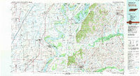
~ Dyersburg TN topo map, 1:100000 scale, 30 X 60 Minute, Historical, 1983, updated 1983
Dyersburg, Tennessee, USGS topographic map dated 1983.
Includes geographic coordinates (latitude and longitude). This topographic map is suitable for hiking, camping, and exploring, or framing it as a wall map.
Printed on-demand using high resolution imagery, on heavy weight and acid free paper, or alternatively on a variety of synthetic materials.
Topos available on paper, Waterproof, Poly, or Tyvek. Usually shipping rolled, unless combined with other folded maps in one order.
- Product Number: USGS-5338842
- Free digital map download (high-resolution, GeoPDF): Dyersburg, Tennessee (file size: 21 MB)
- Map Size: please refer to the dimensions of the GeoPDF map above
- Weight (paper map): ca. 55 grams
- Map Type: POD USGS Topographic Map
- Map Series: HTMC
- Map Verison: Historical
- Cell ID: 67447
- Scan ID: 143888
- Imprint Year: 1983
- Woodland Tint: Yes
- Aerial Photo Year: 1981
- Edit Year: 1983
- Datum: NAD27
- Map Projection: Universal Transverse Mercator
- Map published by Tennessee Valley Authority
- Map Language: English
- Scanner Resolution: 600 dpi
- Map Cell Name: Dyersburg
- Grid size: 30 X 60 Minute
- Date on map: 1983
- Map Scale: 1:100000
- Geographical region: Tennessee, United States
Neighboring Maps:
All neighboring USGS topo maps are available for sale online at a variety of scales.
Spatial coverage:
Topo map Dyersburg, Tennessee, covers the geographical area associated the following places:
- Holbert Corner - Page - Tiptonville - Polk - Wardell - Viar - Douglas - Good Hope - Oak Ridge - Englewood - Tatumville - Sumach - Deco - West Hermondale - Friendship - Netherlands - Acorn Corner - Gobler - Hermondale - South Dyersburg - Haynes - Concord - Maxey - Caruthersville - Miston - Frailie - Nauvoo - Tinkerville - Cunningham - Cottonwood Grove - Tyson Store - Westbrook (historical) - Keefe - Meacham - Blue Bank - Clarkton - Evansville - Lapata - Newell - Owl City - Minnick - Hornbeak - Temples Corner - Woodland Mills - Broadmoor - Peach Orchard - Lenox - Churchton - Gibson - New Markham - Yorkville - Carlston - Marlow - Midway - North Wardell - Cronanville - Channel - Micola - Cottonwood Point - McCutchen Heights - Poplar Ridge - Big Boy Junction - Elbridge - Millsfield - Oakville - Deering Junction - Brent - Portageville - Lake Drive - Hayward - Walnut Log - Forks of the River - Covington - Gibbons - Pleasant Hill - Jenkinsville - Holland - Steele - Templeton - Lane - Union City - Fremont - Samford - Stanley - Moark - Bethel (historical) - Wolverine - Braggadocio - Rives - Bogota - Edgewater Beach - Mackeys - Stancil - Dixie - Highland - Protemus - Stringtown - Newbern - Obion - Richwoods
- Map Area ID: AREA36.536-90-89
- Northwest corner Lat/Long code: USGSNW36.5-90
- Northeast corner Lat/Long code: USGSNE36.5-89
- Southwest corner Lat/Long code: USGSSW36-90
- Southeast corner Lat/Long code: USGSSE36-89
- Northern map edge Latitude: 36.5
- Southern map edge Latitude: 36
- Western map edge Longitude: -90
- Eastern map edge Longitude: -89


