
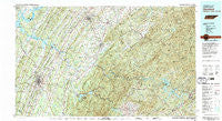
~ Cleveland TN topo map, 1:100000 scale, 30 X 60 Minute, Historical, 1981, updated 1981
Cleveland, Tennessee, USGS topographic map dated 1981.
Includes geographic coordinates (latitude and longitude). This topographic map is suitable for hiking, camping, and exploring, or framing it as a wall map.
Printed on-demand using high resolution imagery, on heavy weight and acid free paper, or alternatively on a variety of synthetic materials.
Topos available on paper, Waterproof, Poly, or Tyvek. Usually shipping rolled, unless combined with other folded maps in one order.
- Product Number: USGS-5338836
- Free digital map download (high-resolution, GeoPDF): Cleveland, Tennessee (file size: 33 MB)
- Map Size: please refer to the dimensions of the GeoPDF map above
- Weight (paper map): ca. 55 grams
- Map Type: POD USGS Topographic Map
- Map Series: HTMC
- Map Verison: Historical
- Cell ID: 67309
- Scan ID: 148985
- Imprint Year: 1981
- Woodland Tint: Yes
- Visual Version Number: 1
- Aerial Photo Year: 1976
- Edit Year: 1981
- Datum: NAD27
- Map Projection: Universal Transverse Mercator
- Map published by Tennessee Valley Authority
- Map Language: English
- Scanner Resolution: 600 dpi
- Map Cell Name: Cleveland
- Grid size: 30 X 60 Minute
- Date on map: 1981
- Map Scale: 1:100000
- Geographical region: Tennessee, United States
Neighboring Maps:
All neighboring USGS topo maps are available for sale online at a variety of scales.
Spatial coverage:
Topo map Cleveland, Tennessee, covers the geographical area associated the following places:
- Marina Hills - Big Spring - Benton Station - East View - Hillsview - Fields of the Wood - Green Meadow - Ogreeta - Sugar Grove - Piney Acres - Patty - Davis Heights - Hopewell Estates - Wehutty - Harbuck - Union Grove - Mount Harmony - Westwood Heights - East Cleveland - Beta - Conasauga - Suburban Hills - Benton - Spring Creek - Tevis - Reliance - Mountainbrook - Jeffrey (historical) - Bates Creek - Wildwood Lake - Goodfield - Rymers (historical) - Brentwood Estates - Hills and Dales - Hooper Acres - Ballplay - Sherwood Forest - North Etowah - Nantahala Estates - Taylor - Rocky Spring - Poplar Hill - Bellefounte - Gibson Farm Subdivision - Cleveland - Martins Creek - Etola - Flint Springs - Grandview - Ellis Mill - Hope Acres - Johnsonville - Fairview - Georgetown - Rafter - Isabella - Tasso - Ironsburg - Heritage Hills - Notchy Creek - Fetzerton (historical) - Smithfield - Jacen Gorbett Subdivision - Wesleyanna - Laurel Ridge - Chestnut Valley - Eureka Hills - Wilson Heights - North Liberty - Citico - Tucker Springs - Lee Estates - Blue Springs - Benton Springs - Meadowview - Peach Orchard - Whisperwood - Grape Creek - Maggies Mill - Macedonia - Holly Springs - Manila - Sunny Point - Nonaburg - Acorn - Ebenezer - Union - Big Creek - Cedar Spring - Turtletown - Calhoun - Bryson - Laurel Springs - Annadale - Hidden Valley - Wetmore - Bent Tree Acres - Coile - Hothouse - Epperson
- Map Area ID: AREA35.535-85-84
- Northwest corner Lat/Long code: USGSNW35.5-85
- Northeast corner Lat/Long code: USGSNE35.5-84
- Southwest corner Lat/Long code: USGSSW35-85
- Southeast corner Lat/Long code: USGSSE35-84
- Northern map edge Latitude: 35.5
- Southern map edge Latitude: 35
- Western map edge Longitude: -85
- Eastern map edge Longitude: -84


