
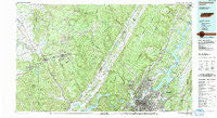
~ Chattanooga TN topo map, 1:100000 scale, 30 X 60 Minute, Historical, 1988, updated 1991
Chattanooga, Tennessee, USGS topographic map dated 1988.
Includes geographic coordinates (latitude and longitude). This topographic map is suitable for hiking, camping, and exploring, or framing it as a wall map.
Printed on-demand using high resolution imagery, on heavy weight and acid free paper, or alternatively on a variety of synthetic materials.
Topos available on paper, Waterproof, Poly, or Tyvek. Usually shipping rolled, unless combined with other folded maps in one order.
- Product Number: USGS-5338834
- Free digital map download (high-resolution, GeoPDF): Chattanooga, Tennessee (file size: 36 MB)
- Map Size: please refer to the dimensions of the GeoPDF map above
- Weight (paper map): ca. 55 grams
- Map Type: POD USGS Topographic Map
- Map Series: HTMC
- Map Verison: Historical
- Cell ID: 67277
- Scan ID: 143829
- Imprint Year: 1991
- Woodland Tint: Yes
- Aerial Photo Year: 1988
- Edit Year: 1988
- Datum: NAD27
- Map Projection: Universal Transverse Mercator
- Map published by Tennessee Valley Authority
- Map Language: English
- Scanner Resolution: 600 dpi
- Map Cell Name: Chattanooga
- Grid size: 30 X 60 Minute
- Date on map: 1988
- Map Scale: 1:100000
- Geographical region: Tennessee, United States
Neighboring Maps:
All neighboring USGS topo maps are available for sale online at a variety of scales.
Spatial coverage:
Topo map Chattanooga, Tennessee, covers the geographical area associated the following places:
- Dallas (historical) - Skyline Park - College Hill - Dogtown - Clearwater Acres - Brainerd Hills - Coalmont - Eastdale - Alpine Heights - Shady Rest - Austin Farm - Fairview - Ardis Mobile Home Park - Olde Mill - Marimont - Holy Hills - Sartain Springs - Towne Hills - East Chattanooga - Timberlinks - Chattanooga - Jeffery Acres - Smithtown - Greens Mill - The Crossroads - Sandalwood Village - Metro Park - Parkshore Estates - Knollwood - Valleybrook - Fair Meadows Mobile Home Park - Dallas Crest - Palisades - Hixson - Orme - Cross Creek - North Soddy - Nickletown - Gruetli-Laager - Old Farm - Oak Grove - Pine Harbor Heights - Lake Dweller - Woodmore - Monteagle - Crabtree Hills - Fanetta Gardens - Lankford Town - Foxwood Heights - Hodgetown - Mowbray - South Brainerd - Riggs Trailer Park - Daisy - Creekwood Terrace - Dayton - Five Points - Brainerd Park - Shirleyton - Pinebrook Estates - Stoneridge - Highland Manor - Melville - Rivermont - Shore Acres - Clifton Hills - Glover Hill - Mount Airy - Avondale - Stuart Heights - Indian Hills - Oak Grove - Mountain Shade Mobile Home Park - Raulstontown - Ruthledge Hill - Concord Heights - Radmoor - Orchard Knob - Elm Hill - Harrison - Holiday Hills - Edgemont Forest - Savannah Peninsula - Fountain Village - East Lake - Green Hills - Tyner Hills - Bartlebaugh - Red Bank - Bushtown - Dallas Hills - Hickory Grove - Lake Village - Hobbs Hill - Beersheba Springs - Laurel Brook - Ware Branch - Sulphur Springs - Ponderosa Pines - Betsy Willis
- Map Area ID: AREA35.535-86-85
- Northwest corner Lat/Long code: USGSNW35.5-86
- Northeast corner Lat/Long code: USGSNE35.5-85
- Southwest corner Lat/Long code: USGSSW35-86
- Southeast corner Lat/Long code: USGSSE35-85
- Northern map edge Latitude: 35.5
- Southern map edge Latitude: 35
- Western map edge Longitude: -86
- Eastern map edge Longitude: -85


