
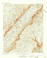
~ Sequatchie Valley TN topo map, 1:62500 scale, 15 X 15 Minute, Historical, 1909, updated 1955
Sequatchie Valley, Tennessee, USGS topographic map dated 1909.
Includes geographic coordinates (latitude and longitude). This topographic map is suitable for hiking, camping, and exploring, or framing it as a wall map.
Printed on-demand using high resolution imagery, on heavy weight and acid free paper, or alternatively on a variety of synthetic materials.
Topos available on paper, Waterproof, Poly, or Tyvek. Usually shipping rolled, unless combined with other folded maps in one order.
- Product Number: USGS-5338806
- Free digital map download (high-resolution, GeoPDF): Sequatchie Valley, Tennessee (file size: 10 MB)
- Map Size: please refer to the dimensions of the GeoPDF map above
- Weight (paper map): ca. 55 grams
- Map Type: POD USGS Topographic Map
- Map Series: HTMC
- Map Verison: Historical
- Cell ID: 62340
- Scan ID: 153371
- Imprint Year: 1955
- Survey Year: 1909
- Datum: NAD27
- Map Projection: Polyconic
- Map published by United States Geological Survey
- Map Language: English
- Scanner Resolution: 600 dpi
- Map Cell Name: Sequatchie Valley
- Grid size: 15 X 15 Minute
- Date on map: 1909
- Map Scale: 1:62500
- Geographical region: Tennessee, United States
Neighboring Maps:
All neighboring USGS topo maps are available for sale online at a variety of scales.
Spatial coverage:
Topo map Sequatchie Valley, Tennessee, covers the geographical area associated the following places:
- Cumberland Spring - West End - Pearson (historical) - Friendship - Liberty Hill - Tanbark (historical) - Hart (historical) - Schoolfield (historical) - Gerren Heights - Tiptop - Pikeville - Luminary - Litton - Seals (historical) - Morgan Springs - Emery Mill - Ogden - Summer City - Mount Crest - Gladecreek (historical) - Cranmore Cove - Cooper Mill - Cold Spring - North Dayton - Saratoga Springs - Paine Spring - Ninemile - Bellview - Morgantown - Rainy (historical) - New Harmony - Melvine
- Map Area ID: AREA35.7535.5-85.25-85
- Northwest corner Lat/Long code: USGSNW35.75-85.25
- Northeast corner Lat/Long code: USGSNE35.75-85
- Southwest corner Lat/Long code: USGSSW35.5-85.25
- Southeast corner Lat/Long code: USGSSE35.5-85
- Northern map edge Latitude: 35.75
- Southern map edge Latitude: 35.5
- Western map edge Longitude: -85.25
- Eastern map edge Longitude: -85


