
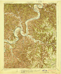
~ Gainesboro TN topo map, 1:62500 scale, 15 X 15 Minute, Historical, 1929
Gainesboro, Tennessee, USGS topographic map dated 1929.
Includes geographic coordinates (latitude and longitude). This topographic map is suitable for hiking, camping, and exploring, or framing it as a wall map.
Printed on-demand using high resolution imagery, on heavy weight and acid free paper, or alternatively on a variety of synthetic materials.
Topos available on paper, Waterproof, Poly, or Tyvek. Usually shipping rolled, unless combined with other folded maps in one order.
- Product Number: USGS-5338682
- Free digital map download (high-resolution, GeoPDF): Gainesboro, Tennessee (file size: 11 MB)
- Map Size: please refer to the dimensions of the GeoPDF map above
- Weight (paper map): ca. 55 grams
- Map Type: POD USGS Topographic Map
- Map Series: HTMC
- Map Verison: Historical
- Cell ID: 54442
- Scan ID: 153384
- Woodland Tint: Yes
- Survey Year: 1925
- Datum: NAD
- Map Projection: Polyconic
- Map published by United States Geological Survey
- Map Language: English
- Scanner Resolution: 600 dpi
- Map Cell Name: Gainesboro
- Grid size: 15 X 15 Minute
- Date on map: 1929
- Map Scale: 1:62500
- Geographical region: Tennessee, United States
Neighboring Maps:
All neighboring USGS topo maps are available for sale online at a variety of scales.
Spatial coverage:
Topo map Gainesboro, Tennessee, covers the geographical area associated the following places:
- Freewill - Baptist Ridge - Gainesboro - Center Grove - Turkeytown (historical) - New Hope - Turkey Creek (historical) - Haydenburg - Nameless - Cub Creek - McCoinsville - Hurricane - Rough Point - Harmony - Greenwood - Dodson Branch - Carlock - Mayfield (historical) - Stone - Sugar Creek - Columbus Hill - Morrison Creek - Shady Grove - Dudney Hill - Antioch - Old Antioch - Flynns Lick - Mount Union - Whitleyville - New Salem - Burristown - Pacific (historical)
- Map Area ID: AREA36.536.25-85.75-85.5
- Northwest corner Lat/Long code: USGSNW36.5-85.75
- Northeast corner Lat/Long code: USGSNE36.5-85.5
- Southwest corner Lat/Long code: USGSSW36.25-85.75
- Southeast corner Lat/Long code: USGSSE36.25-85.5
- Northern map edge Latitude: 36.5
- Southern map edge Latitude: 36.25
- Western map edge Longitude: -85.75
- Eastern map edge Longitude: -85.5


