
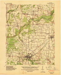
~ Dyersburg TN topo map, 1:62500 scale, 15 X 15 Minute, Historical, 1939, updated 1943
Dyersburg, Tennessee, USGS topographic map dated 1939.
Includes geographic coordinates (latitude and longitude). This topographic map is suitable for hiking, camping, and exploring, or framing it as a wall map.
Printed on-demand using high resolution imagery, on heavy weight and acid free paper, or alternatively on a variety of synthetic materials.
Topos available on paper, Waterproof, Poly, or Tyvek. Usually shipping rolled, unless combined with other folded maps in one order.
- Product Number: USGS-5338668
- Free digital map download (high-resolution, GeoPDF): Dyersburg, Tennessee (file size: 7 MB)
- Map Size: please refer to the dimensions of the GeoPDF map above
- Weight (paper map): ca. 55 grams
- Map Type: POD USGS Topographic Map
- Map Series: HTMC
- Map Verison: Historical
- Cell ID: 53635
- Scan ID: 147976
- Imprint Year: 1943
- Woodland Tint: Yes
- Edit Year: 1939
- Datum: NAD
- Map Projection: Polyconic
- Map published by United States Army Corps of Engineers
- Map published by United States Department of War
- Map Language: English
- Scanner Resolution: 600 dpi
- Map Cell Name: Dyersburg
- Grid size: 15 X 15 Minute
- Date on map: 1939
- Map Scale: 1:62500
- Geographical region: Tennessee, United States
Neighboring Maps:
All neighboring USGS topo maps are available for sale online at a variety of scales.
Spatial coverage:
Topo map Dyersburg, Tennessee, covers the geographical area associated the following places:
- Lenox - Miston - Newbern - Rehoboth - Viar - Millsfield - Locust Grove - Bogota - Evansville - South Dyersburg - Friendship - Mount Hope - Calvary - Jenkinsville - Big Boy Junction - Finley - Cunningham - Cloverdale - Dyersburg - Bishop - Lane - Meacham - Broadmoor - Cat Corner - Band Mill - Good Hope - RoEllen - Middle City - Nauvoo - Rock Springs - Maxey
- Map Area ID: AREA36.2536-89.5-89.25
- Northwest corner Lat/Long code: USGSNW36.25-89.5
- Northeast corner Lat/Long code: USGSNE36.25-89.25
- Southwest corner Lat/Long code: USGSSW36-89.5
- Southeast corner Lat/Long code: USGSSE36-89.25
- Northern map edge Latitude: 36.25
- Southern map edge Latitude: 36
- Western map edge Longitude: -89.5
- Eastern map edge Longitude: -89.25


