
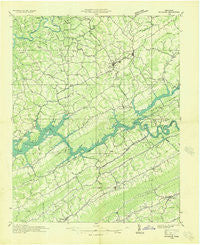
~ Rutledge TN topo map, 1:48000 scale, 15 X 15 Minute, Historical, 1936
Rutledge, Tennessee, USGS topographic map dated 1936.
Includes geographic coordinates (latitude and longitude). This topographic map is suitable for hiking, camping, and exploring, or framing it as a wall map.
Printed on-demand using high resolution imagery, on heavy weight and acid free paper, or alternatively on a variety of synthetic materials.
Topos available on paper, Waterproof, Poly, or Tyvek. Usually shipping rolled, unless combined with other folded maps in one order.
- Product Number: USGS-5338612
- Free digital map download (high-resolution, GeoPDF): Rutledge, Tennessee (file size: 8 MB)
- Map Size: please refer to the dimensions of the GeoPDF map above
- Weight (paper map): ca. 55 grams
- Map Type: POD USGS Topographic Map
- Map Series: HTMC
- Map Verison: Historical
- Cell ID: 61867
- Scan ID: 153358
- Woodland Tint: Yes
- Field Check Year: 1936
- Datum: NAD27
- Map Projection: Polyconic
- Advance: Yes
- Planimetric: Yes
- Map published by Tennessee Valley Authority
- Map Language: English
- Scanner Resolution: 600 dpi
- Map Cell Name: Rutledge
- Grid size: 15 X 15 Minute
- Date on map: 1936
- Map Scale: 1:48000
- Geographical region: Tennessee, United States
Neighboring Maps:
All neighboring USGS topo maps are available for sale online at a variety of scales.
Spatial coverage:
Topo map Rutledge, Tennessee, covers the geographical area associated the following places:
- Lily Grove - Head of Barren - Cupp Mill - Ambro (historical) - Williams Mill - Beeler Mill - Edmondson (historical) - Bald Hill (historical) - Powder Springs - Springdale - Lulaville - Oakman (historical) - Carr Branch - Sandlick - Little Barren - Clouds - New Tazewell - Pennington Chapel - Mason Springs - Navehill - Sycamore (historical) - Washburn - Rutledge - Puncheon Camp - Duo - Hurst Mill - Clear Springs (historical) - Chittum - Highberry Trailer Park - Saddle Ridge - Elm Springs - Goin - Williams Springs - Sunset - Ashby (historical) - Big Barren - Lone Mountain - Minkton (historical) - Murphy Mill - Tazewell - Liberty Hill - Clinch River (historical) - Acuff - Haynes (historical) - Chestnut Ridge - Snodgrass - Old Cedar Fork
- Map Area ID: AREA36.536.25-83.75-83.5
- Northwest corner Lat/Long code: USGSNW36.5-83.75
- Northeast corner Lat/Long code: USGSNE36.5-83.5
- Southwest corner Lat/Long code: USGSSW36.25-83.75
- Southeast corner Lat/Long code: USGSSE36.25-83.5
- Northern map edge Latitude: 36.5
- Southern map edge Latitude: 36.25
- Western map edge Longitude: -83.75
- Eastern map edge Longitude: -83.5


