
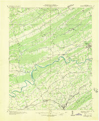
~ Rogersville TN topo map, 1:48000 scale, 15 X 15 Minute, Historical, 1935
Rogersville, Tennessee, USGS topographic map dated 1935.
Includes geographic coordinates (latitude and longitude). This topographic map is suitable for hiking, camping, and exploring, or framing it as a wall map.
Printed on-demand using high resolution imagery, on heavy weight and acid free paper, or alternatively on a variety of synthetic materials.
Topos available on paper, Waterproof, Poly, or Tyvek. Usually shipping rolled, unless combined with other folded maps in one order.
- Product Number: USGS-5338610
- Free digital map download (high-resolution, GeoPDF): Rogersville, Tennessee (file size: 8 MB)
- Map Size: please refer to the dimensions of the GeoPDF map above
- Weight (paper map): ca. 55 grams
- Map Type: POD USGS Topographic Map
- Map Series: HTMC
- Map Verison: Historical
- Cell ID: 74355
- Scan ID: 153357
- Woodland Tint: Yes
- Field Check Year: 1935
- Datum: NAD27
- Map Projection: Polyconic
- Advance: Yes
- Planimetric: Yes
- Map published by Tennessee Valley Authority
- Map Language: English
- Scanner Resolution: 600 dpi
- Map Cell Name: Rogersville
- Grid size: 15 X 15 Minute
- Date on map: 1935
- Map Scale: 1:48000
- Geographical region: Tennessee, United States
Neighboring Maps:
All neighboring USGS topo maps are available for sale online at a variety of scales.
Spatial coverage:
Topo map Rogersville, Tennessee, covers the geographical area associated the following places:
- Jaybird - Cain Mill - Glendale Acres - Bright (historical) - Henardtown - Holston Hills - Yount Town - Cardinal Hills - Pleasant Hill - Music Acres - New Hope - Hyatt Acres - Russellville - Luther - Cuba - Alumwell - Persia - Galbraith Springs - Longtown (historical) - Bulls Gap - Choptack - Spruce Pine - Trent Valley - Clinchview Heights - Rogersville - Austins Mill - Cheeks Crossroads - Galbraith - Klondike - Camelot - Duck Creek - Cloud Creek - Altonville - Coran - Whitesburg - Fairfield Acres - Needmore - Mooresburg Springs - Treadway - Shiloh - Lee Valley - East Manor - Quarryville (historical) - Lakemont Cabin Area - Saint Clair - Beech Grove - White Horn - Kentucky Heights - Otes - Mooresburg - Lakeshore Estates - Murrelltown - Friendship
- Map Area ID: AREA36.536.25-83.25-83
- Northwest corner Lat/Long code: USGSNW36.5-83.25
- Northeast corner Lat/Long code: USGSNE36.5-83
- Southwest corner Lat/Long code: USGSSW36.25-83.25
- Southeast corner Lat/Long code: USGSSE36.25-83
- Northern map edge Latitude: 36.5
- Southern map edge Latitude: 36.25
- Western map edge Longitude: -83.25
- Eastern map edge Longitude: -83


