
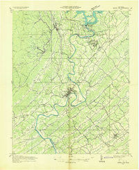
~ Norris Dam TN topo map, 1:48000 scale, 15 X 15 Minute, Historical, 1936
Norris Dam, Tennessee, USGS topographic map dated 1936.
Includes geographic coordinates (latitude and longitude). This topographic map is suitable for hiking, camping, and exploring, or framing it as a wall map.
Printed on-demand using high resolution imagery, on heavy weight and acid free paper, or alternatively on a variety of synthetic materials.
Topos available on paper, Waterproof, Poly, or Tyvek. Usually shipping rolled, unless combined with other folded maps in one order.
- Product Number: USGS-5338606
- Free digital map download (high-resolution, GeoPDF): Norris Dam, Tennessee (file size: 8 MB)
- Map Size: please refer to the dimensions of the GeoPDF map above
- Weight (paper map): ca. 55 grams
- Map Type: POD USGS Topographic Map
- Map Series: HTMC
- Map Verison: Historical
- Cell ID: 60310
- Scan ID: 149283
- Woodland Tint: Yes
- Field Check Year: 1936
- Datum: NAD27
- Map Projection: Polyconic
- Advance: Yes
- Planimetric: Yes
- Map published by Tennessee Valley Authority
- Map Language: English
- Scanner Resolution: 600 dpi
- Map Cell Name: Norris Dam
- Grid size: 15 X 15 Minute
- Date on map: 1936
- Map Scale: 1:48000
- Geographical region: Tennessee, United States
Neighboring Maps:
All neighboring USGS topo maps are available for sale online at a variety of scales.
Spatial coverage:
Topo map Norris Dam, Tennessee, covers the geographical area associated the following places:
- Cherokee Ridge - Broad Acres - Jackson Square - Cherrybrook - The Wye - Bethel - Northhampton Acres - Grand Oaks - Heiskell - Elza - Offutt - Peak - Ponderosa Hills - Bell Bridge - Clinch View - Lazy Acres - Maples - Idlewood Acres - Powell Heights - Edgemoor - Cumberland View Estates - Fraterville - Emory Heights - Hinds Creek (historical) - Belmont - Hillvale - Slatestone - Powell - Marlow - Shadow Wood - Twi-lite Zone Mobile Home Park - Briceville - Valley View Heights - Leinarts - Minersville - Panther (historical) - Granite - Treeville - Bud (historical) - Sherwood Estates - Washington Heights - Westwood Estates - Claxton - Norris Park - Rocky Top - Valley View - Mayview Heights - Mill Creek - Kirkstall - Cane Creek (historical) - Cumberland View Mobile Home Park - Seeber Flats - Knapp (historical) - Beech Grove - Clinch River (historical) - Dossett - Lakewood - Ivory - Sites Mobile Home Park - Conasauga Heights - Deep Springs - Spring Hill - Dutch Valley - South Clinton - Bull Run - Emory Valley - Laurel - Andersonville - Glenwood - Gooseneck - Edgewood Heights - Laurel Grove - Clinton - Norris - Disney - Emory Hills - Medford - Blowing Springs
- Map Area ID: AREA36.2536-84.25-84
- Northwest corner Lat/Long code: USGSNW36.25-84.25
- Northeast corner Lat/Long code: USGSNE36.25-84
- Southwest corner Lat/Long code: USGSSW36-84.25
- Southeast corner Lat/Long code: USGSSE36-84
- Northern map edge Latitude: 36.25
- Southern map edge Latitude: 36
- Western map edge Longitude: -84.25
- Eastern map edge Longitude: -84


