
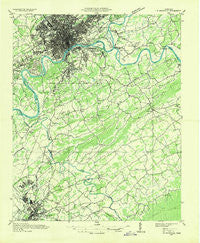
~ Knoxville TN topo map, 1:48000 scale, 15 X 15 Minute, Historical, 1935
Knoxville, Tennessee, USGS topographic map dated 1935.
Includes geographic coordinates (latitude and longitude). This topographic map is suitable for hiking, camping, and exploring, or framing it as a wall map.
Printed on-demand using high resolution imagery, on heavy weight and acid free paper, or alternatively on a variety of synthetic materials.
Topos available on paper, Waterproof, Poly, or Tyvek. Usually shipping rolled, unless combined with other folded maps in one order.
- Product Number: USGS-5338594
- Free digital map download (high-resolution, GeoPDF): Knoxville, Tennessee (file size: 9 MB)
- Map Size: please refer to the dimensions of the GeoPDF map above
- Weight (paper map): ca. 55 grams
- Map Type: POD USGS Topographic Map
- Map Series: HTMC
- Map Verison: Historical
- Cell ID: 56268
- Scan ID: 147970
- Woodland Tint: Yes
- Field Check Year: 1936
- Datum: NAD27
- Map Projection: Polyconic
- Advance: Yes
- Planimetric: Yes
- Map published by Tennessee Valley Authority
- Map Language: English
- Scanner Resolution: 600 dpi
- Map Cell Name: Knoxville
- Grid size: 15 X 15 Minute
- Date on map: 1935
- Map Scale: 1:48000
- Geographical region: Tennessee, United States
Neighboring Maps:
All neighboring USGS topo maps are available for sale online at a variety of scales.
Spatial coverage:
Topo map Knoxville, Tennessee, covers the geographical area associated the following places:
- Elajay (historical) - Stock Creek - Southbrook - Grandview - Coster Yards - Bungalow - Johnson Road - Cowan Springs - Littlebrook - Pitner (historical) - Meadowbrook - Bassel Addition - Lyons View - Mooreland Heights - Bayview - Newell Station - Springbrook - Bays Mountain Estates - Neubert Springs - Peppermint Hills - Oldfield Addition - Huskey Valley - Edgewood Acres - Timberlake - Island Home - South Hall - Colonial Village - Rivertrace - Sevier Heights - Meades Quarry - Rivertrace - Fairfield - Valley Grove - Alcoa - Lakeview Estates - Twelve Oaks - Woodfield Park - Woodmont Addition - Hannum Addition - Westminister Ridge - Grandview Heights - Arrowhead - Topside - Deep Creek - Kingsley Station - Rockford - Shooks - West Haven - Farrport - Fox Hills - West View - Airport Plaza - South Knoxville - Seymour Heights - Mule Hollow - Lakemoor Hills - Prospect - Kimberlin Heights - Mimosa Heights - Westfields - West Springbrook - Glenmore Estates - Marble City - Shooks Gap - Riverbend - Cold Springs - Summit Hills - Oak View - Sevier Home - Blount Beach - Forest Hills - Forks of the River - Tara Estates - Spur Trailer Park - Vose - Meadowood - Crossfield - Amerene (historical) - Notime (historical) - Bank (historical) - Vestal - Crenshaw - Whites Village - Chandler - New Hopewell - Scenic Terrace - Burlington - Rocky Waters - Maryville - Twin Oak Estates - Belmont Addition - Mountain Trace - Welwyn (historical) - Wildwood - Plainfield addition - Eggers Addition - Singleton - West Knoxville - Providence - Cherokee Park
- Map Area ID: AREA3635.75-84-83.75
- Northwest corner Lat/Long code: USGSNW36-84
- Northeast corner Lat/Long code: USGSNE36-83.75
- Southwest corner Lat/Long code: USGSSW35.75-84
- Southeast corner Lat/Long code: USGSSE35.75-83.75
- Northern map edge Latitude: 36
- Southern map edge Latitude: 35.75
- Western map edge Longitude: -84
- Eastern map edge Longitude: -83.75


