
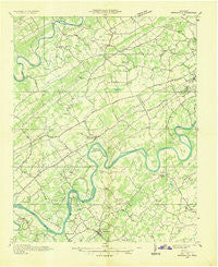
~ Friendship TN topo map, 1:48000 scale, 15 X 15 Minute, Historical, 1936
Friendship, Tennessee, USGS topographic map dated 1936.
Includes geographic coordinates (latitude and longitude). This topographic map is suitable for hiking, camping, and exploring, or framing it as a wall map.
Printed on-demand using high resolution imagery, on heavy weight and acid free paper, or alternatively on a variety of synthetic materials.
Topos available on paper, Waterproof, Poly, or Tyvek. Usually shipping rolled, unless combined with other folded maps in one order.
- Product Number: USGS-5338590
- Free digital map download (high-resolution, GeoPDF): Friendship, Tennessee (file size: 7 MB)
- Map Size: please refer to the dimensions of the GeoPDF map above
- Weight (paper map): ca. 55 grams
- Map Type: POD USGS Topographic Map
- Map Series: HTMC
- Map Verison: Historical
- Cell ID: 54412
- Scan ID: 149874
- Woodland Tint: Yes
- Field Check Year: 1936
- Datum: NAD27
- Map Projection: Polyconic
- Advance: Yes
- Map published by Tennessee Valley Authority
- Map Language: English
- Scanner Resolution: 600 dpi
- Map Cell Name: Friendsville
- Grid size: 15 X 15 Minute
- Date on map: 1936
- Map Scale: 1:48000
- Geographical region: Tennessee, United States
Neighboring Maps:
All neighboring USGS topo maps are available for sale online at a variety of scales.
Spatial coverage:
Topo map Friendship, Tennessee, covers the geographical area associated the following places:
- Oak Grove Heights - Galewood - Peninsular Estates - Disco - Ewing (historical) - Busselltown - Wexford Downs - Berkshire Wood - Montvue - Cedar Hills - Martel Estates East - Hickory Woods - Hickory Hills - Hidden Hills - Gooseneck - Village Green - Westlyn - Sweet Briar - Mentor - Byington - Carlton - Piney Grove Mobile Home Park - Mount Tabor - Third Creek - Karns - Eagles Landing Mobile Home Park - Boyd - Hidden Valley - Byrd Chapel - Fox Den - Country Estates Mobile Home Park - Kingsgate - Rothwood - Bonneville Estates - Smoky View Estates - Concord - Lovell - Garland - Mount Vernon - Volunteer Village - Westborough - Belle-Aire - Lovell Road Mobile Home Park - Arline - Sevenoaks - Meadowbrook - Wedgewood Hills - Woodland Acres - Ashley Oaks - Farmington - Wooded Acres - Virtue - Pleasant Hills - Pumpkin Center - Ridgedale - Sequoyah Heights - Tekoa - Ford - Burchfield Heights - Belmont West - Edington (historical) - Martel - Mahoney Mill - Stonebrook - Castaway Cove - Gulf Park - Kensington - Canby Hills - Old Glory - West Hills - Crestwood Hills - Cedar Springs - Lovell Heights - Coulter Shoals - Ebenezer - Farrington - Camelot - West Emory - Green Meadow - Lakewood - Spanish Trails - Kingston Woods - West Forest - Greenwood Heights - Highland Hills - Aldenwood Park - Amherst - Thornton - Dixie Lee Junction - Plum Creek - Trails End - Kingston Hills - Scenic Point Estates - Twin Springs - Station West - Northshore Woods - Cactus Cove - Brentwood - Woodchase - Deane Hill
- Map Area ID: AREA3635.75-84.25-84
- Northwest corner Lat/Long code: USGSNW36-84.25
- Northeast corner Lat/Long code: USGSNE36-84
- Southwest corner Lat/Long code: USGSSW35.75-84.25
- Southeast corner Lat/Long code: USGSSE35.75-84
- Northern map edge Latitude: 36
- Southern map edge Latitude: 35.75
- Western map edge Longitude: -84.25
- Eastern map edge Longitude: -84


