
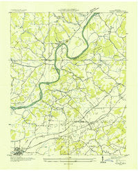
~ Talbott TN topo map, 1:24000 scale, 7.5 X 7.5 Minute, Historical, 1935
Talbott, Tennessee, USGS topographic map dated 1935.
Includes geographic coordinates (latitude and longitude). This topographic map is suitable for hiking, camping, and exploring, or framing it as a wall map.
Printed on-demand using high resolution imagery, on heavy weight and acid free paper, or alternatively on a variety of synthetic materials.
Topos available on paper, Waterproof, Poly, or Tyvek. Usually shipping rolled, unless combined with other folded maps in one order.
- Product Number: USGS-5337880
- Free digital map download (high-resolution, GeoPDF): Talbott, Tennessee (file size: 7 MB)
- Map Size: please refer to the dimensions of the GeoPDF map above
- Weight (paper map): ca. 55 grams
- Map Type: POD USGS Topographic Map
- Map Series: HTMC
- Map Verison: Historical
- Cell ID: 44206
- Scan ID: 155859
- Woodland Tint: Yes
- Field Check Year: 1935
- Datum: NAD27
- Map Projection: Polyconic
- Advance: Yes
- Planimetric: Yes
- Map published by Tennessee Valley Authority
- Map Language: English
- Scanner Resolution: 600 dpi
- Map Cell Name: Talbott
- Grid size: 7.5 X 7.5 Minute
- Date on map: 1935
- Map Scale: 1:24000
- Geographical region: Tennessee, United States
Neighboring Maps:
All neighboring USGS topo maps are available for sale online at a variety of scales.
Spatial coverage:
Topo map Talbott, Tennessee, covers the geographical area associated the following places:
- Withers Subdivision - Fox Den - Buell Acres - Panther Creek (historical) - Westgate - Meadowview - Melody Acres - Smokerise - Quail Hollow - Hunters Ridge - Talbott - Cedar Hills - Britton Acres - Oakland - Wa-Ni Village - Lakeshore Gardens - Navaho Hills - Patterson Hills - Beacon Hills - Willow Springs - Briarcliff View - Pleasantview Acres - Panther Hills - Alpha Heights - Purkey Estates - Cedar Hill Park - Jackson Heights - Shiloh - West Lake Estates - Rolling Acres - Panther Lake - Lake Park - Arrow Hills - Cherokee - Rambling Hills - Prima Estates - Woodcrest Hills - Keister - Cedar Hills - Seven Oaks - Alpha - Lowe Acres - Pleasant view - Kathy Hills - Green Acres - Bluegrass - Rock Town - Stithsville (historical) - May Springs (historical) - May Acres - Wilderness Shores - Wood Acres - Point Seven
- Map Area ID: AREA36.2536.125-83.5-83.375
- Northwest corner Lat/Long code: USGSNW36.25-83.5
- Northeast corner Lat/Long code: USGSNE36.25-83.375
- Southwest corner Lat/Long code: USGSSW36.125-83.5
- Southeast corner Lat/Long code: USGSSE36.125-83.375
- Northern map edge Latitude: 36.25
- Southern map edge Latitude: 36.125
- Western map edge Longitude: -83.5
- Eastern map edge Longitude: -83.375


