
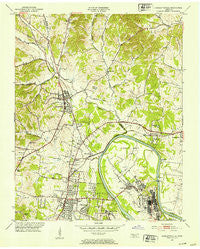
~ Goodlettsville TN topo map, 1:24000 scale, 7.5 X 7.5 Minute, Historical, 1952, updated 1953
Goodlettsville, Tennessee, USGS topographic map dated 1952.
Includes geographic coordinates (latitude and longitude). This topographic map is suitable for hiking, camping, and exploring, or framing it as a wall map.
Printed on-demand using high resolution imagery, on heavy weight and acid free paper, or alternatively on a variety of synthetic materials.
Topos available on paper, Waterproof, Poly, or Tyvek. Usually shipping rolled, unless combined with other folded maps in one order.
- Product Number: USGS-5334600
- Free digital map download (high-resolution, GeoPDF): Goodlettsville, Tennessee (file size: 12 MB)
- Map Size: please refer to the dimensions of the GeoPDF map above
- Weight (paper map): ca. 55 grams
- Map Type: POD USGS Topographic Map
- Map Series: HTMC
- Map Verison: Historical
- Cell ID: 70208
- Scan ID: 149748
- Imprint Year: 1953
- Woodland Tint: Yes
- Aerial Photo Year: 1950
- Field Check Year: 1952
- Datum: NAD27
- Map Projection: Polyconic
- Map published by United States Geological Survey
- Map Language: English
- Scanner Resolution: 600 dpi
- Map Cell Name: Goodlettsville
- Grid size: 7.5 X 7.5 Minute
- Date on map: 1952
- Map Scale: 1:24000
- Geographical region: Tennessee, United States
Neighboring Maps:
All neighboring USGS topo maps are available for sale online at a variety of scales.
Spatial coverage:
Topo map Goodlettsville, Tennessee, covers the geographical area associated the following places:
- Goodlettsville - Driftwood Park - Rayon City - Panorama Harbor - High Chaparral - Highland Acres - Rolling Acres - Rockland - Delray Park Estates - North Hills Estates - Lohman - Twin Valley - Solitude Acres - Northcreek Commons - Madison - Amqui - Hillwood - Edenwold - Millersville - Old Hickory - Walton (historical) - Cedarbrook
- Map Area ID: AREA36.37536.25-86.75-86.625
- Northwest corner Lat/Long code: USGSNW36.375-86.75
- Northeast corner Lat/Long code: USGSNE36.375-86.625
- Southwest corner Lat/Long code: USGSSW36.25-86.75
- Southeast corner Lat/Long code: USGSSE36.25-86.625
- Northern map edge Latitude: 36.375
- Southern map edge Latitude: 36.25
- Western map edge Longitude: -86.75
- Eastern map edge Longitude: -86.625


