
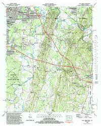
~ East Ridge TN topo map, 1:24000 scale, 7.5 X 7.5 Minute, Historical, 1982, updated 1983
East Ridge, Tennessee, USGS topographic map dated 1982.
Includes geographic coordinates (latitude and longitude). This topographic map is suitable for hiking, camping, and exploring, or framing it as a wall map.
Printed on-demand using high resolution imagery, on heavy weight and acid free paper, or alternatively on a variety of synthetic materials.
Topos available on paper, Waterproof, Poly, or Tyvek. Usually shipping rolled, unless combined with other folded maps in one order.
- Product Number: USGS-5334082
- Free digital map download (high-resolution, GeoPDF): East Ridge, Tennessee (file size: 14 MB)
- Map Size: please refer to the dimensions of the GeoPDF map above
- Weight (paper map): ca. 55 grams
- Map Type: POD USGS Topographic Map
- Map Series: HTMC
- Map Verison: Historical
- Cell ID: 13481
- Scan ID: 147461
- Imprint Year: 1983
- Woodland Tint: Yes
- Aerial Photo Year: 1975
- Edit Year: 1982
- Field Check Year: 1975
- Datum: NAD27
- Map Projection: Transverse Mercator
- Map published by United States Geological Survey
- Map Language: English
- Scanner Resolution: 600 dpi
- Map Cell Name: East Ridge
- Grid size: 7.5 X 7.5 Minute
- Date on map: 1982
- Map Scale: 1:24000
- Geographical region: Tennessee, United States
Neighboring Maps:
All neighboring USGS topo maps are available for sale online at a variety of scales.
Spatial coverage:
Topo map East Ridge, Tennessee, covers the geographical area associated the following places:
- Mana Estates - Irwin Hills - Mitchell Acres - Lansdell Park - Post Oak - Blevins Acre - Brookvale Estates - Old Mill Trace - Walnut Hills - Old Fort Estates - Newnan Springs - Ellie Spring - Belvoir Terrace - Castle Park - Dietz - Burning Bush - Boynton - Opeleika (historical) - Swanson Mill - Dallondale - Cinderella Hills - Boyd Highlands - Liles Addition - Summit Hill - Dafron - Pleasant Grove - East Brainerd - Waverly Park - New Liberty - Poplar Springs - Harris Hills - Harris Hills - Graysville - Foster Hills - Blue Spring - Scenic Hills - East Boynton - Indian Springs - Love Hill - Morris Estates - Westside - McDonald Acres
- Map Area ID: AREA3534.875-85.25-85.125
- Northwest corner Lat/Long code: USGSNW35-85.25
- Northeast corner Lat/Long code: USGSNE35-85.125
- Southwest corner Lat/Long code: USGSSW34.875-85.25
- Southeast corner Lat/Long code: USGSSE34.875-85.125
- Northern map edge Latitude: 35
- Southern map edge Latitude: 34.875
- Western map edge Longitude: -85.25
- Eastern map edge Longitude: -85.125


