
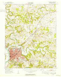
~ Clarksville TN topo map, 1:24000 scale, 7.5 X 7.5 Minute, Historical, 1951, updated 1953
Clarksville, Tennessee, USGS topographic map dated 1951.
Includes geographic coordinates (latitude and longitude). This topographic map is suitable for hiking, camping, and exploring, or framing it as a wall map.
Printed on-demand using high resolution imagery, on heavy weight and acid free paper, or alternatively on a variety of synthetic materials.
Topos available on paper, Waterproof, Poly, or Tyvek. Usually shipping rolled, unless combined with other folded maps in one order.
- Product Number: USGS-5333474
- Free digital map download (high-resolution, GeoPDF): Clarksville, Tennessee (file size: 13 MB)
- Map Size: please refer to the dimensions of the GeoPDF map above
- Weight (paper map): ca. 55 grams
- Map Type: POD USGS Topographic Map
- Map Series: HTMC
- Map Verison: Historical
- Cell ID: 8954
- Scan ID: 148974
- Imprint Year: 1953
- Woodland Tint: Yes
- Aerial Photo Year: 1951
- Field Check Year: 1951
- Datum: NAD27
- Map Projection: Polyconic
- Map published by United States Army Corps of Engineers
- Map Language: English
- Scanner Resolution: 600 dpi
- Map Cell Name: Clarksville
- Grid size: 7.5 X 7.5 Minute
- Date on map: 1951
- Map Scale: 1:24000
- Geographical region: Tennessee, United States
Neighboring Maps:
All neighboring USGS topo maps are available for sale online at a variety of scales.
Spatial coverage:
Topo map Clarksville, Tennessee, covers the geographical area associated the following places:
- Barkwood - Beacon Hills - Bellamy Court - Maplewood - Rivermont - Rudolphtown - Ashland Hills - Belle Forest - Colonial Court - Georgetown - Forest Hills - Swan Lake Village - Willow Bend - Colony Estates - West Creek - Eastern Hills - Cardinal Acres - Cedarbrook - Peartree - Shady Bluff - Wedgewood Estates - Belmont - Chesapeake Estates - Knollwood - Heritage Estates - Springs Inn Estates - Wingate - Endsville - Clarksville - Grasslands - Hillview Estates - Northside Estates - Balsam Estates - Wingate West - Hundred Acres - Valley View - Hillwood - Spring Valley - Buckner Pine Subdivision - Seventy-Six Estates - Foxmoor - Evergreen Estates - Saint Bethlehem - Rushton - Briarwood - Cedarcroft - River Run - Rossview - Craigmont - Volunteer Estates - Meadow Lane - Charlestown Estates - Woodland Estates - Dunbar Cave
- Map Area ID: AREA36.62536.5-87.375-87.25
- Northwest corner Lat/Long code: USGSNW36.625-87.375
- Northeast corner Lat/Long code: USGSNE36.625-87.25
- Southwest corner Lat/Long code: USGSSW36.5-87.375
- Southeast corner Lat/Long code: USGSSE36.5-87.25
- Northern map edge Latitude: 36.625
- Southern map edge Latitude: 36.5
- Western map edge Longitude: -87.375
- Eastern map edge Longitude: -87.25


