
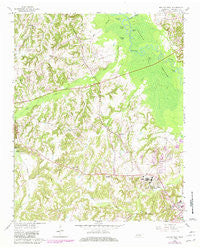
~ Bolivar West TN topo map, 1:24000 scale, 7.5 X 7.5 Minute, Historical, 1961, updated 1981
Bolivar West, Tennessee, USGS topographic map dated 1961.
Includes geographic coordinates (latitude and longitude). This topographic map is suitable for hiking, camping, and exploring, or framing it as a wall map.
Printed on-demand using high resolution imagery, on heavy weight and acid free paper, or alternatively on a variety of synthetic materials.
Topos available on paper, Waterproof, Poly, or Tyvek. Usually shipping rolled, unless combined with other folded maps in one order.
- Product Number: USGS-5332814
- Free digital map download (high-resolution, GeoPDF): Bolivar West, Tennessee (file size: 12 MB)
- Map Size: please refer to the dimensions of the GeoPDF map above
- Weight (paper map): ca. 55 grams
- Map Type: POD USGS Topographic Map
- Map Series: HTMC
- Map Verison: Historical
- Cell ID: 4745
- Scan ID: 149448
- Imprint Year: 1981
- Woodland Tint: Yes
- Photo Revision Year: 1981
- Aerial Photo Year: 1975
- Edit Year: 1981
- Field Check Year: 1961
- Datum: NAD27
- Map Projection: Polyconic
- Map published by United States Geological Survey
- Map Language: English
- Scanner Resolution: 600 dpi
- Map Cell Name: Bolivar West
- Grid size: 7.5 X 7.5 Minute
- Date on map: 1961
- Map Scale: 1:24000
- Geographical region: Tennessee, United States
Neighboring Maps:
All neighboring USGS topo maps are available for sale online at a variety of scales.
Spatial coverage:
Topo map Bolivar West, Tennessee, covers the geographical area associated the following places:
- Turkey Pond - Hardeman County Landfill - Bolivar Junior High School - Potters Creek - Nuckolls Cemetery - Bartlett Chapel Cemetery - Western Mental Health Institute - Bolivar Elementary School - Green Grove Church - Round Pond - Green Grove School (historical) - Hardeman County Golf Course - Bartlett Chapel - Norment Cemetery - Bethelehem Baptist Church - Clover Lakes - Short Creek - Central High School - Bethlehem Church - Bolivar Church of Christ - Parrans Chapel - Clover Creek - Commissioner District 1 - Brushy Pond - Oak Dain Creek - Clear Creek - City of Bolivar - Parker Cemetery - Pirtle Pond - Bethlehem School - Saint Marys Catholic Church
- Map Area ID: AREA35.37535.25-89.125-89
- Northwest corner Lat/Long code: USGSNW35.375-89.125
- Northeast corner Lat/Long code: USGSNE35.375-89
- Southwest corner Lat/Long code: USGSSW35.25-89.125
- Southeast corner Lat/Long code: USGSSE35.25-89
- Northern map edge Latitude: 35.375
- Southern map edge Latitude: 35.25
- Western map edge Longitude: -89.125
- Eastern map edge Longitude: -89


