
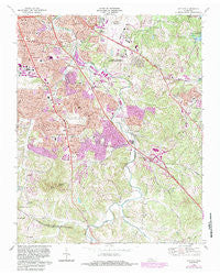
~ Antioch TN topo map, 1:24000 scale, 7.5 X 7.5 Minute, Historical, 1968, updated 1984
Antioch, Tennessee, USGS topographic map dated 1968.
Includes geographic coordinates (latitude and longitude). This topographic map is suitable for hiking, camping, and exploring, or framing it as a wall map.
Printed on-demand using high resolution imagery, on heavy weight and acid free paper, or alternatively on a variety of synthetic materials.
Topos available on paper, Waterproof, Poly, or Tyvek. Usually shipping rolled, unless combined with other folded maps in one order.
- Product Number: USGS-5332346
- Free digital map download (high-resolution, GeoPDF): Antioch, Tennessee (file size: 17 MB)
- Map Size: please refer to the dimensions of the GeoPDF map above
- Weight (paper map): ca. 55 grams
- Map Type: POD USGS Topographic Map
- Map Series: HTMC
- Map Verison: Historical
- Cell ID: 1196
- Scan ID: 143592
- Imprint Year: 1984
- Woodland Tint: Yes
- Photo Revision Year: 1983
- Aerial Photo Year: 1980
- Edit Year: 1983
- Datum: NAD27
- Map Projection: Polyconic
- Map published by United States Geological Survey
- Map Language: English
- Scanner Resolution: 600 dpi
- Map Cell Name: Antioch
- Grid size: 7.5 X 7.5 Minute
- Date on map: 1968
- Map Scale: 1:24000
- Geographical region: Tennessee, United States
Neighboring Maps:
All neighboring USGS topo maps are available for sale online at a variety of scales.
Spatial coverage:
Topo map Antioch, Tennessee, covers the geographical area associated the following places:
- Oglesby - Wilkerson (historical) - Nashboro Village - Hickory Valley Estates - Rural Hill - Tusculum - Brookview Estates - Cane Ridge - Radnor - Colewood Acres - Barclay Square - Bakertown - Oakwood Terrace - Glencliff - Raintree Forest - Wrencoe - Antioch - Antioch Park - In-A-Vale-Estates - Myrtlewood Estates - Monte Carlo Estates - Una - Woodbine - Providence - Beverly Heights - Fair Oaks - Town Park Estates - Paragon Mills - Kenilworth Estates - Huntington Ridge Estates - Whispering Hills - Gilroy (historical) - Pebble Creek - Curry (historical)
- Map Area ID: AREA36.12536-86.75-86.625
- Northwest corner Lat/Long code: USGSNW36.125-86.75
- Northeast corner Lat/Long code: USGSNE36.125-86.625
- Southwest corner Lat/Long code: USGSSW36-86.75
- Southeast corner Lat/Long code: USGSSE36-86.625
- Northern map edge Latitude: 36.125
- Southern map edge Latitude: 36
- Western map edge Longitude: -86.75
- Eastern map edge Longitude: -86.625


