
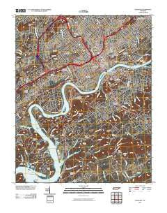
~ Knoxville TN topo map, 1:24000 scale, 7.5 X 7.5 Minute, Historical, 2010
Knoxville, Tennessee, USGS topographic map dated 2010.
Includes geographic coordinates (latitude and longitude). This topographic map is suitable for hiking, camping, and exploring, or framing it as a wall map.
Printed on-demand using high resolution imagery, on heavy weight and acid free paper, or alternatively on a variety of synthetic materials.
Topos available on paper, Waterproof, Poly, or Tyvek. Usually shipping rolled, unless combined with other folded maps in one order.
- Product Number: USGS-5151926
- Free digital map download (high-resolution, GeoPDF): Knoxville, Tennessee (file size: 28 MB)
- Map Size: please refer to the dimensions of the GeoPDF map above
- Weight (paper map): ca. 55 grams
- Map Type: POD USGS Topographic Map
- Map Series: US Topo
- Map Verison: Historical
- Cell ID: 23904
- Datum: North American Datum of 1983
- Map Projection: Transverse Mercator
- Map Cell Name: Knoxville
- Grid size: 7.5 X 7.5 Minute
- Date on map: 2010
- Map Scale: 1:24000
- Geographical region: Tennessee, United States
Neighboring Maps:
All neighboring USGS topo maps are available for sale online at a variety of scales.
Spatial coverage:
Topo map Knoxville, Tennessee, covers the geographical area associated the following places:
- Lonsdale - Welwyn (historical) - Marble City - Riverbend - Deep Creek - Knoxville - Burlington - Mount Olive - Spur Trailer Park - Topside - Crenshaw - Westminister Ridge - Timberlake - Mooreland Heights - Park City - West View - Island Home - Lincoln Park - Mockingbird Hill - Middlebrook Heights - Lyons View - South Knoxville - West Knoxville - Southbrook - Vestal - Arrowhead - Coster Yards - Forest Hills - Lakemoor Hills - Sequoyah Hills - Kingsley Station - Bonny Kate - West Haven - Colonial Village
- Map Area ID: AREA3635.875-84-83.875
- Northwest corner Lat/Long code: USGSNW36-84
- Northeast corner Lat/Long code: USGSNE36-83.875
- Southwest corner Lat/Long code: USGSSW35.875-84
- Southeast corner Lat/Long code: USGSSE35.875-83.875
- Northern map edge Latitude: 36
- Southern map edge Latitude: 35.875
- Western map edge Longitude: -84
- Eastern map edge Longitude: -83.875


