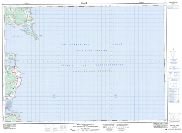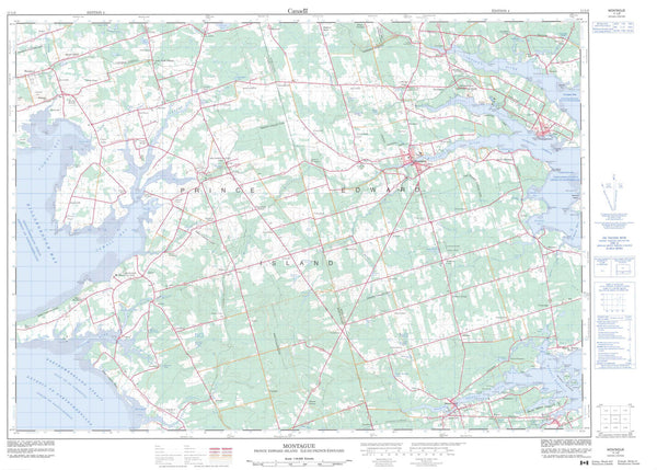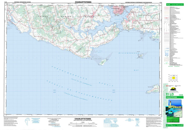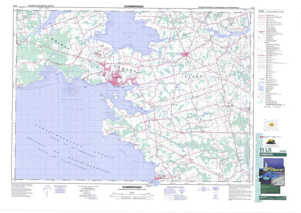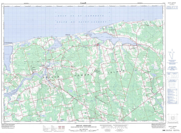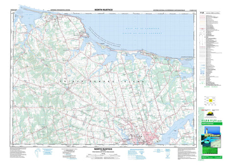
011L06 North Rustico Canada topo map, 1:50,000 scale
011L06 North Rustico NRCAN topographic map.
Includes UTM and GPS geographic coordinates (latitude and longitude). This 50k scale map is suitable for hiking, camping, and exploring, or you could frame it as a wall map.
Printed on-demand using high resolution, on heavy weight and acid free paper, or as an upgrade on a variety of synthetic materials.
Topos available on paper, Waterproof, Poly, or Tyvek. Usually shipping rolled, unless combined with other folded maps in one order.
- Product Number: NRCAN-011L06
- Parent Topo: TOPO-011L
- Map ID also known as: 011L06, 11L6, 11L06
- Unfolded Size: Approximately 26" high by 36" wide
- Weight (paper map): ca. 55 grams
- Map Type: POD NRCAN Topographic Map
- Map Scale: 1:50,000
- Geographical region: Prince Edward Island, Canada
Neighboring Maps:
All neighboring Canadian topo maps are available for sale online at 1:50,000 scale.
Purchase the smaller scale map covering this area: Topo-011L
Spatial coverage:
Topo map sheet 011L06 North Rustico covers the following places:
- Brackley Bay - Chapel Creek - Covehead Bay - Covehead Harbour - Currys Cove - Doyle Cove - Doyles Cove - Golfe du Saint-Laurent - Granville Creek - Gulf of St. Lawrence - Jimmy Angus Cove - Lukes Creek - MacDonalds Cove - MacDougalls Cove - Marshfield Creek - McCallum Creek - Mermaid Cove - New London Bay - New London Harbour - North Rustico Harbour - Oyster Cove - Rustico Bay - Todd Creek - Tracadie Bay - Tracadie Harbour - Walkers Cove - Walkers Cove - Winter Bay - Winter Creek - Brackley Beach - Cavendish Beach - Dalvay Beach - Heartz Shore - North Rustico Beach - Shaws Beach - Stanhope Beach - Beachgrove Point - Brackley Point - Cape Stanhope - Cape Turner - Cavendish Capes - Cove Head - Currys Point - Dockies Point - Doyles Point - Falcon Point - Grand Pere Point - Hornes Point - Kellys Point - Lockes Point - McMillan Point - Munns Point - Orby Head - Pickering Point - Pickerings Point - Queens Point - Red Point - Strawberry Point - Warrens Point - Charlottetown - Charlottetown - Lot 21 - Lot 22 - Lot 23 - Lot 24 - Lot 29 - Lot 30 - Lot 31 - Lot 32 - Lot 33 - Lot 34 - Lot 35 - Lot 48 - Lot 67 - Queens - Ellis Island - MacLeods Island - McEwens Island - Poplar Island - Prince Edward Island - Robinsons Island - Rustico Island - Andrews Pond - Bagnalls Pond - Balderstons Pond - Bells Pond - Bradalbane Pond - Breadalbane Pond - Campbell Pond - Campbells Pond - Carraghers Pond - Cass Pond - Clarkes Pond - Clarke's Pond - Coles Pond - Dalvay Lake - Dalvay Pond - Elliotts Pond - Gates Pond - Graham Rogers Lake - Hardys Pond - Henrys Pond - Lake of Shining Waters - Long Pond - Lower Simpsons Pond - MacEacherns Lake - MacKeys Pond - MacNeills Pond - Malletts Pond - Marshalls Pond - Matters Pond - McKays Pond - McMillans Pond - Mermaid Pond - Moores Pond - Murphys Pond - Officers Pond - Parsons Pond - Rackhams Pond - Rollings Pond - Sherrens Pond - Stevensons Pond - Taylors Pond - Upper Simpsons Pond - Warrens Pond - Willis Pond - Mount Ryan Hill - Ardgowan National Historic Site of Canada - Brookvale Provincial Park - Dalvay-by-the-Sea Hotel National Historic Site of Canada - Dalvay-by-the-Sea National Historic Site of Canada - Devil's Punchbowl Provincial Park - L.M. Montgomery's Cavendish National Historic Site of Canada - Lieu historique national du Canada Ardgowan - Lieu historique national du Canada Dalvay-by-the-Sea - Lieu historique national du Canada de l'Hôtel-Dalvay-by-the-Sea - Lieu historique national du Canada du Cavendish-de-L.-M.-Montgomery - Parc national du Canada de l'Île-du-Prince-Édouard - Prince Edward Island National Park of Canada - Île-du-Prince-Édouard - Prince Edward Island - Andersons Creek - Appletree Creek - Auld Creek - Bells Creek - Black River - Black River - Brocklesby River - Brocklesby River - Clyde River - Coles Creek - Crooked Creek - Curtis Creek - De Sable River - DeSable River - Doirons Creek - Douses Creek - Dunk River - East (Hillsborough) River - East Branch Westmoreland River - Eliot River - Ellens Creek - Founds River - French Fort Creek - Frenchfort Creek - Grahams Creek - Grahams Road Brook - Granville Creek - Hermitage Creek - Hillsborough River - Hope River - Hornes Creek - Hornes Creek - Howells Brook - Hunter River - Johnston River - Johnstons River - Kehough Creek - MacArthurs Creek - MacIntyres Creek - Matheson Creek - Mill Brook - Mill Cove Brook - Mill Creek - Millers Creek - Milton Creek - North (Yorke) River - North Creek - North River - Old Mill River - Parsons Creek - Quinns Brook - Scotts Creek - Smelt Creek - Southwest River - Spring Garden Creek - Stanley River - Trout River - Warren Grove Creek - Watts Creek - West (Eliot) River - West River - Westmoreland River - Westmoreland River - Westmorland River - Westmorland River - Wheatley River - Winter River - Winter River - Wrights Creek - Yorke River - Cornwall - Anglo Rustico - Bayview - Bedford - Bedford Corner - Bedford Station - Bonwell - Brackley - Brackley Beach - Brackley Point - Brookfield - Brookvale - Bungay - Campbellton - Campbelton - Cavendish - Clyde - Colville - Corran Ban - Corranban - Corranban Bridge - Covehead - Covehead Road - Cymbria - Dalvay by the Sea - Darlington - Donaldston - Dunstaffnage - East Royalty - East Wiltshire - Ebenezer - Elliott - Elliotts - Emyvale - Found Mills - Founds Mills - Frederickton - Fredericton - Fredericton Station - French Fort - French Village - Frenchfort - Glen Valley - Glynde River - Grand Tracadie - Granville - Green Bay - Green Gables - Greenvale - Greenville - Hampshire - Harrington - Hartsville - Hazel Grove - Hazelgrove - Highfield - Hillsborough Park - Hope River - Hunter River - Hunters River - Johnstons River - Kelly Cross - Kellys Cross - Kingston - LewisPoint - Lincoln - Little York - Little York - Loyalist - Maplewood - Marshfield - Martin - Mayfield - Mermaid - Mermaid Farm - Mill Cove - Millcove - Millvale - Milton - Milton Station - Mount Ryan - New Glasgow - New Glasgow Mills - New Wiltshire - North Milton - North River - North Rustico Harbour - North Wiltshire - Oyster Bed Bridge - Oysterbed Bridge - Parkdale - Pleasant Grove - Pleasant Valley - Rennies Road - Rose Valley - Royalty Junction - Rustico - Rusticoville - Sherwood - South Granville - South Rustico - Spring Park - Springton - Springvale - St. Ann - St. Dunstan - St. Dunstan's - St. Marys - St. Patricks - Stanchel - Stanhope - Stanhope Bayshore - Stanhope by the Sea - Stanley Bridge - Suffolk - Thorndyke - Toronto - Trilby - Tyrone - Union - Union Road - Upper Westmorland - West Covehead - West Royalty - Westmoreland - Westmorland - Wheatley River - Wiltshire - Winsloe - Winsloe North - Winsloe Road - York - Brackley - Breadalbane - Darlington - Grand Tracadie - Hampshire - Hunter River - Kingston - Miltonvale Park - New Haven-Riverdale - North River - North Rustico - North Shore - North Wiltshire - Pleasant Grove - Stanley Bridge, Hope River, Bayview, Cavendish and North Rustico - Union Road - Warren Grove - West Royalty - Winsloe - Winsloe South - York