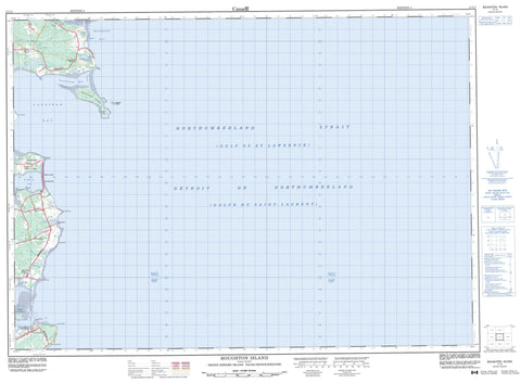
011L01 Boughton Island Canada topo map, 1:50,000 scale
011L01 Boughton Island NRCAN topographic map.
Includes UTM and GPS geographic coordinates (latitude and longitude). This 50k scale map is suitable for hiking, camping, and exploring, or you could frame it as a wall map.
Printed on-demand using high resolution, on heavy weight and acid free paper, or as an upgrade on a variety of synthetic materials.
Topos available on paper, Waterproof, Poly, or Tyvek. Usually shipping rolled, unless combined with other folded maps in one order.
- Product Number: NRCAN-011L01
- Parent Topo: TOPO-011L
- Map ID also known as: 011L01, 11L1, 11L01
- Unfolded Size: Approximately 26" high by 36" wide
- Weight (paper map): ca. 55 grams
- Map Type: POD NRCAN Topographic Map
- Map Scale: 1:50,000
- Geographical region: Prince Edward Island, Canada
Neighboring Maps:
All neighboring Canadian topo maps are available for sale online at 1:50,000 scale.
Purchase the smaller scale map covering this area: Topo-011L
Spatial coverage:
Topo map sheet 011L01 Boughton Island covers the following places:
- Boughton Bay - Cardigan Bay - Golfe du Saint-Laurent - Gulf of St. Lawrence - Launching Bay - MacHerrons Creek - MacPhersons Cove - McPherson Cove - Murray Harbour - Oyster Creek - Reynolds Creek - St. Mary Bay - St. Marys Bay - Mosquito Sands - Poverty Beach - Beach Point - Boughton Point - Boughton Spit - Bruce Point - Burnt Point - Cape Bear - Cape Sharp - Cardigan Point - Cody Point - Cody Point - Des Barres Point - DesBarres Point - Graham Point - Hicken Point - Irvine Point - Irvings Cape - Irvings Point - Launching Point - Murray Head - Old Ferry Spit - Oldstore Point - Panmure Head - Penny Point - Red Head - Red Point - Sable Point - Smith Point - Solander Point - Terras Point - Détroit de Northumberland - Northumberland Strait - Kings - Lot 54 - Lot 55 - Lot 63 - Boughton Island - Gordons Island - Launching Island - Murray Islands - Panmure Island - Prince Edward Island - Condons Pond - Gaspereaux Pond - Graham Pond - Launching Pond - Little Pond - MacLures Pond - MacPhersons Pond - Morrison Pond - Steeles Pond - Panmure Island Provincial Park - Île-du-Prince-Édouard - Prince Edward Island - Black Creek - Boughton River - Dirty River - Dunns Creek - Mosquito Creek - Seal River - Bear Reef - Boughton Ledge - Cardigan Shoal - Fishermans Bank - Graham Ledge - Panmure Ledge - Panmure Shoal - Beach Point - Boughton Island - De Gros Marsh - DeGros Marsh - Gaspereaux - Launching Place - Murray Harbour North - Panmure Island - Pembroke - De Gros Marsh - DeGros Marsh