
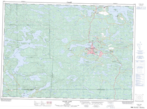
041J07 Elliot Lake Canada topo map, 1:50,000 scale
041J07 Elliot Lake NRCAN topographic map.
Includes UTM and GPS geographic coordinates (latitude and longitude). This 50k scale map is suitable for hiking, camping, and exploring, or you could frame it as a wall map.
Printed on-demand using high resolution, on heavy weight and acid free paper, or as an upgrade on a variety of synthetic materials.
Topos available on paper, Waterproof, Poly, or Tyvek. Usually shipping rolled, unless combined with other folded maps in one order.
- Product Number: NRCAN-041J07
- Parent Topo: TOPO-041J
- Map ID also known as: 041J07, 41J7, 41J07
- Unfolded Size: Approximately 26" high by 36" wide
- Weight (paper map): ca. 55 grams
- Map Type: POD NRCAN Topographic Map
- Map Scale: 1:50,000
- Geographical region: Ontario, Canada
Neighboring Maps:
All neighboring Canadian topo maps are available for sale online at 1:50,000 scale.
Purchase the smaller scale map covering this area: Topo-041J
Spatial coverage:
Topo map sheet 041J07 Elliot Lake covers the following places:
- 68 Bay - Baker Bay - Baker's Bay - Brundage Bay - Camp 7 Bay - Camp Bay - MacDonald's Bay - Merseth's Bay - Shamas Bay - South Bay - Teacher's Bay - Vezeau's Bay - The New Beach - The Old Beach - Allen's Point - Brown's Point - Conecho Point - Hamil's Point - Paradise Point - Sandy Point - Stover's Point - Thomas Point - 68 Narrows - Butterfield Narrows - Graveyard Narrows - Elliot Lake - Cataract Falls - The Waterfalls - 143 - 144 - 149 - 150 - 155 - 156 - 161 - 162 - 167 - 168 - Algoma - Beange - Bolger - Bouck - Buckles - Cobden - Esten - Gunterman - Jogues - Joubin - Juillette - Kamichisitit - Lewis - Long - Mack - McGiverin - Proctor - Scarfe - Spragge - Striker - Timmermans - Blueberry Island - Graveyard Island - John Blue Island - Knowles Island - Lee Island - Lee's Island - Little Blueberry Island - Long Island - Matinenda Island - Monument Island - Roman Island - Swiss Island - Sylvah Island - Admiral Lake - Banana Lake - Bawden Lakes - Bawden Lakes - Bay Lake - Bearhead Lake - Beaver Lake - Benedict Lake - Big Moon Lake - Black Lake - Blanche Lake - Boundary Lake - Camp Lake - Canyon Lake - Caribou Lake - Caroline Lake - Cataract Lake - Charlie Lake - Chiblow Lake - Christie Lake - Cinder Lake - Claim Lake - Coffee Lake - Coffee Lake - Commander Lake - Cream Lake - Crotch Lake - Crow Lake - David Lake - Denison Lake - Depot Lake - Duck Lake - Duck Lake - Dumbell Lake - Dunlop Lake - Dyelle Lake - Elephant Lake - Elliot Lake - Emerald Lake - Esten Lake - Evans Lake - First Lake - Flag Lake - Flying Goose Lake - Gander Lake - Granary Lake - Grandeur Lake - Green Lake - Gullbeak Lake - Gusty Lake - Halfmoon Lake - Hector Lake - Heron Lake - Hope Lake - Horne Lake - Hough Lake - Intersect Lake - Jowsey Lake - Keelor Lake - Kenmey Lake - Kings Lake - Laderoute Lake - Lake Duborne - Lake Hope - Lake of the Mountains - Link Lake - Little Duck Lake - Little May Lake - Little Moon Lake - Loon Lake - Lower Cranberry Lake - Lower Mace Lake - Magog Lake - Manfred Lake - Marsh Lake - Marshland Lake - Mather Lake - Mather's Lake - Matinenda Lake - May Lake - McCabe Lake - McCarthy Lake - McFadden Lake - McGiverin Lake - Mellon Lake - Metevier Lake - Mink Lake - Moon Lake - Nordic Lake - Norse Lake - North Nordic Lake - Northspan Lake - Ouellette Lake - Pardee Lake - Pathfinder Lake - Peak Lake - Pear Lake - Penelope Lake - Pike Lake - Pistol Lake - Popeye Lake - Poppy Lake - Porridge Lake - Quimby Lake - Quirke Lake - Rioux Lake - Rodge Lake - Rossmere Lake - Rusty Lake - Ryan Lake - Ryan Lake - Rye Lake - Second Lake - Sheriff Lake - Skull Lake - Slipper Lake - Slipper Lake - Snafu Lake - South Lake - Spence Lake - Spillane Lake - Spring Lake - Spur Lake - Stinky Lake - Stinson Lake - Stollery Lake - Stone Lake - Strouth Lake - Summers Lake - Tea Lake - Tea Lake - Teasdale Lake - Trout Lake - Turtle Lake - Upper Cranberry Lake - Vanhorn Lake - Westner Lake - Williams Lake - Wise Lake - Zeke Lake - Beaver Mountain - Fire Tower Mountain - Mount Dufour - The North Shore - Glenn N. Crombie Conservation Reserve - Matinenda Provincial Park - Bearhead Creek - Bearhead Creek - Black Creek - Black Creek - Blind River - Christie Creek - Cranberry Creek - Crooked Creek - Duck Creek - Granary Creek - Laderoute Creek - Magog Creek - Marcellus Creek - Marshland River - Marshland River - McCarthy Creek - Moon Creek - Pistol Creek - Rochester Creek - Serpent River - Sheriff Creek - Summers Creek - Winter Portage - Bagi's Rock - Flat Rocks - Good Odds Shoal - Rooster Rock - The High Rocks - Blind River - Nordic Lake - Nordic Townsite


