
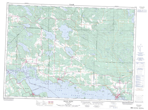
041J05 Bruce Mines Canada topo map, 1:50,000 scale
041J05 Bruce Mines NRCAN topographic map.
Includes UTM and GPS geographic coordinates (latitude and longitude). This 50k scale map is suitable for hiking, camping, and exploring, or you could frame it as a wall map.
Printed on-demand using high resolution, on heavy weight and acid free paper, or as an upgrade on a variety of synthetic materials.
Topos available on paper, Waterproof, Poly, or Tyvek. Usually shipping rolled, unless combined with other folded maps in one order.
- Product Number: NRCAN-041J05
- Parent Topo: TOPO-041J
- Map ID also known as: 041J05, 41J5, 41J05
- Unfolded Size: Approximately 26" high by 36" wide
- Weight (paper map): ca. 55 grams
- Map Type: POD NRCAN Topographic Map
- Map Scale: 1:50,000
- Geographical region: Ontario, Canada
Neighboring Maps:
All neighboring Canadian topo maps are available for sale online at 1:50,000 scale.
Purchase the smaller scale map covering this area: Topo-041J
Spatial coverage:
Topo map sheet 041J05 Bruce Mines covers the following places:
- Bamageseck Bay - Brickyard Bay - Bruce Bay - Bullhead Bay - Dead Boy's Bay - Desjardins Bay - Fisher Bay - Garden Bay - Gawas Bay - Hay Bay - Hole in the Wall - Joe Dollar Bay - Macbeth Bay - McLeod's Bay - Portlock Harbour - Quebec Bay - Smelter Bay - Old Mill Beach - Bowker Point - Canoe Point - Dunlevie Point - Eagle Point - Gravel Point - Graveyard Point - Humbug Point - Jacks Point - Kensington Point - Killaly Point - McCort Point - Mink Point - Old Quarry Point - Poundnet Point - Whippoorwill Point - Woodman Point - Woodward Point - Devils Gap - North Channel - St. Joseph Channel - Wilson Channel - Aberdeen - Aberdeen Additional - Algoma - Bridgland - Day - Galbraith - Haughton - Hilton - Jocelyn - Johnson - Kirkwood - Laird - Macdonald - Meredith - Plummer - Plummer Additional - Rose - St. Joseph - Tarbutt - Tarbutt Additional - Thessalon - Agate Island - Alice Island - Bamford Island - Belford Island - Birch Island - Black Island - Boswell Island - Calf Island - Campement d'Ours Island - Cedar Island - Chevalier Islands - Clinton Island - Coatsworth Island - Colby Island - Colter Island - Copper Island - Cox Island - Cricket Island - Davy Islands - Dawson Island - Devils Island - Edith Island - Frechette Island - Fremlin Island - French Island - Gooseberry Island - Green Island - Hat Island - Holmes Island - House Island - Jacks Island - Lambe Islands - Larry Island - Lasher Island - Little Island - Long Island - McKay Island - McNab Island - McQueen Island - Montague Islands - Munroe Islands - One Tree Island - Outlaw Islands - Pallideau Island - Picture Island - Plummer Island - Poole Island - Poole Islands - Poole Islands - Portlock Island - Sapper Island - Shrove Island - Silver Island - St. Ange Island - St. Joseph Island - Story Island - Twyning Islands - Vinton Island - Walker Island - Weller Islands - Whiskey Rock - White Island - Wilson Island - Bailey Lake - Bass Lake - Becking Lake - Bocage Lake - Bog Lake - Caribou Lake - Centre Lake - Cloudy Lake - Desbarats Lake - Diamond Lake - Eleanor Lake - Emerson Lake - Gibboney Lake - Gordon Lake - Grey Duck Lake - Havilah Lake - Ickta Lake - Indian Lake - Iron Lake - Lac Huron - Leslie Lake - Lonely Lake - Loyal Lake - Madill Lake - McCarrel Lake - McCarroll Lake - McCluskie Lake - McCreight's Pond - Meredith Lake - Ottertail Lake - Peter Lake - Rainbow Lake - Randolph Lake - Reserve Lake - Rock Lake - Rose Lake - Round Lake - Shaw Dam Lake - Shellrock Lake - Siwash Lake - Tea Lake - Tenass Lake - Tower Lake - Tunnel Lake - Wanamaker Lake - Wilson Lake - East Hill - Roberts Hill - Day and Bright Additional - Hilton - Huron Shores - Johnson - Laird - Macdonald, Meredith and Aberdeen Additional - Plummer Additional - St. Joseph - Tarbutt and Tarbutt Additional - Thessalon - Thompson - Galbraith Peatland Conservation Reserve - Rose Lake Dune Peatland Complex Conservation Reserve - Thessalon River Delta/Rock Lake Red Oak Conservation Reserve - Little Rapids - Anderson Creek - Bar River - Black Creek - Bridgland River - Coffee Creek - Desbarats River - Jagger's Creek - Jordon Creek - Jordon Creek - Little Thessalon River - Macbeth Creek - McKinnon Creek - Mississagi River - Rivière Ste-Marie - St. Mary River - St. Marys River - Stobie Creek - Stoby Creek - Sucker Creek - Sucker Creek - Thessalon River - Two Tree River - Twotree Creek - Wanamaker Creek - Africa Rock - Alicia Rock - Asia Rocks - Aurora Bank - Avis Ground - Bald Rock - Beer Rock - Berry Patches - Biggar Rock - Canada Rock - Carmona Rock - Cooper Rock - Crebo Rock - Cruiser Rock - Duncan Rock - East Sister Rock - Fisher Shoal - Fly Rock - Frank Reef - Fremlin Reef - Gereaux Rock - Hannah Ground - Hawkes Shoal - Hurt Rock - Jackson Rock - Jennie Rock - Jermyn Rock - Joly Rock - Kalulah Rock - Kate Rock - Long Bank - Maria Rock - Marks Bank - McKay Reef - McNab Reef - McPhail Rock - Middle Bank - Minnie Rocks - North Sister Rock - Piercy Rocks - Pine Rock - Plummer Bank - Prout Rock - Shenick Reef - Short Rock - Sister Rocks - South Sister Rock - Ten Rib Rock - Vixen Rocks - Weightman Rock - West Sister Rock - Bruce Mines - Thessalon - Ansonia - Bruce Station - Cloudslee - Desbarats - Dunns Valley - Gawas - Glen Otter - Gordon Lake - Havilah - Isbester - Leeburn - Little Rapids - Nesterville - Nestorville - Ophir - Plummer - Portlock - Rock Lake - Rydal Bank - Sherwood - Sylvan Valley - Isbester Swamp - Hilton Beach


