
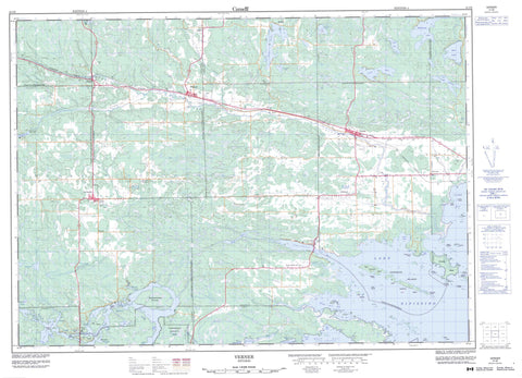
041I08 Verner Canada topo map, 1:50,000 scale
041I08 Verner NRCAN topographic map.
Includes UTM and GPS geographic coordinates (latitude and longitude). This 50k scale map is suitable for hiking, camping, and exploring, or you could frame it as a wall map.
Printed on-demand using high resolution, on heavy weight and acid free paper, or as an upgrade on a variety of synthetic materials.
Topos available on paper, Waterproof, Poly, or Tyvek. Usually shipping rolled, unless combined with other folded maps in one order.
- Product Number: NRCAN-041I08
- Parent Topo: TOPO-041I
- Map ID also known as: 041I08, 41I8, 41I08
- Unfolded Size: Approximately 26" high by 36" wide
- Weight (paper map): ca. 55 grams
- Map Type: POD NRCAN Topographic Map
- Map Scale: 1:50,000
- Geographical region: Ontario, Canada
Neighboring Maps:
All neighboring Canadian topo maps are available for sale online at 1:50,000 scale.
Purchase the smaller scale map covering this area: Topo-041I
Spatial coverage:
Topo map sheet 041I08 Verner covers the following places:
- Baie Aubin - Baie Lamoureux - Bear Bay - Bear Bay - Black Rock Bay - Cache Bay - Collins Bay - East Bay - Indian Portage Bay - Keith's Bay - McLeod Bay - Merganser Bay - Middle West Bay - Mud Bay - Musky Bay - Northwest Bay - Pike Bay - Round Bay - Sawmill Bay - South Bay - West Arm - West Arm of Lake Nipissing - West Bay - Whissel Bay - Goulais Point - Pike Point - The Elbow - Doster's Narrow - Nipissing Ouest - Rivière des Français - Black Rock - Appleby - Badgerow - Bertram - Caldwell - Casimir - Cherriman - Dunnet - Field - Haddo - Hagar - Hugel - Jennings - Kirkpatrick - Latchford - Loudon - Macpherson - Nipissing - Ratter - Springer - Sudbury - Bev Island - Blueberry Island - Cache Island - Centre Island - Chaput's Island - Coopers Island - East Hardwood Island - Garden Island - Gull Islands - Hardwood Islands - Harry's Island - Île à Chaput - Little Islands - Little Oak Island - Maskinonge Island - McLeod Islands - Moss Island - Oak Island - Pedlar Island - Phil's Island - Rock Islands - Sawbill Island - Snake Island - The Island - Umbrella Island - West Hardwood Island - Badgerow Lake - Bain Lake - Bear Lake - Berry Lake - Buckwheat Lake - Cache Lake - Cross Lake - Deer Lake - Duff Lake - Hugel Lake - Lac Caché - Lac Nepewassi - Lac Nipissing - Lac Tonnerre - Lake Nipissing - Lily Lake - Martinson Lake - Moss Lake - Muskosung Lake - Nepewassi Lake - Ratter Lake - Tanner Lake - Waubamac Lake - Caldwell - Casimir, Jennings and Appleby - Cosby and Mason - Cosby, Mason and Martland - Field - Hagar - Martland - Ratter and Dunnet - Springer - Cache Bay Wetland Conservation Reserve - Field Township Conservation Reserve - Mashkinonje Provincial Park - Amateewakea River - Bear Creek - Cache River - Courchesne's Creek - Deer Creek - Duck Creek - Kesagami River - Kiyask River - Little Cache River - Macpherson Creek - Maskinonge Creek - Muskrat Creek - Nepewassi River - Perrault's Creek - Ramsay Creek - Riberdy Creek - Rice Creek - Rivière Veuve - Veuve River - West River - Bald Rocks - Hay Rock - Pickerel Rock - French River - Markstay-Warren - St.-Charles - West Nipissing - Appleby Corner - Caderette - Casimir - Dunnet - Dunnet's Corner - Hagar - Hugel - Kipling - Kirk - Lavigne - Millerand - Notre Dame du Lac - St. Charles - Verner - Warren - West Arm


