
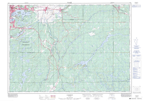
041I07 Coniston Canada topo map, 1:50,000 scale
041I07 Coniston NRCAN topographic map.
Includes UTM and GPS geographic coordinates (latitude and longitude). This 50k scale map is suitable for hiking, camping, and exploring, or you could frame it as a wall map.
Printed on-demand using high resolution, on heavy weight and acid free paper, or as an upgrade on a variety of synthetic materials.
Topos available on paper, Waterproof, Poly, or Tyvek. Usually shipping rolled, unless combined with other folded maps in one order.
- Product Number: NRCAN-041I07
- Parent Topo: TOPO-041I
- Map ID also known as: 041I07, 41I7, 41I07
- Unfolded Size: Approximately 26" high by 36" wide
- Weight (paper map): ca. 55 grams
- Map Type: POD NRCAN Topographic Map
- Map Scale: 1:50,000
- Geographical region: Ontario, Canada
Neighboring Maps:
All neighboring Canadian topo maps are available for sale online at 1:50,000 scale.
Purchase the smaller scale map covering this area: Topo-041I
Spatial coverage:
Topo map sheet 041I07 Coniston covers the following places:
- Barlow Bay - CPR Bay - Crane's Nest Bay - Frenchman's Bay - Hermit's Bay - Levern Bay - Mine Bay - Morel's Bay - South Bay - West Arm - West Arm of Lake Nipissing - First Beach - Second Beach - Grand Sudbury - Greater Sudbury - Rivière des Français - White Pine Chutes - Appleby - Awrey - Broder - Burwash - Cherriman - Cleland - Dill - Dryden - Hagar - Halifax - Hawley - Hendrie - Hoskin - Jennings - Laura - McKim - Neelon - Secord - Servos - Sudbury - Tilton - Bass Island - Berry Island - Blueberry Island - Bryn Heulog Island - Don Island - Du Caillaud Island - Duck Island - Galliard Island - Gordon Island - Green Island - Ida Island - McCrea Island - McMahons Island - McNaughton Island - Meda Island - Norway Island - One Mile Island - Picnic Island - Pike Island - Potters Island - Romanet Island - Salter Island - Swansea Island - Swiss Island - Alice Lake - Baby Lake - Band Lake - Barlow Lake - Barlow Lake - Bennett Lake - Bethel Lake - Big Marsh Lake - Big Paddy Lake - Big Pine Lake - Birch Lake - Bluff Lake - Boulder Lake - Brodill Lake - Burnt Lake - Camp Lake - Campbell Lake - Carrie Lake - Chief Lake - Clam Lake - Cord Lake - Cranberry Lake - Creek's End Lake - Crooked Lake - Crowley Lake - Daisy Lake - Dill Lake - Doctor's Pond - Doyle Lake - Eau Sale Pond - Elbow Lake - Forest Lake - Four Corner Lake - Graham Lake - Grant Lake - Gull Lake - Horseshoe Lake - Judge Lake - Jumbo Lake - Kasten Lake - Lac Nepewassi - Lac Ramsey - Lac Red Deer - Lake Laurentian - Linton Lake - Little Judge Lake - Little Raft Lake - Long Lake - McFarlane Lake - Millerd Lake - Minnow Lake - Mud Lake - Mud Lake - Nepahwin Lake - Nepewassi Lake - Offtrail Lake - Paddy Lake - Perch Lake - Rabbit Lake - Raft Lake - Ramsey Lake - Red Deer Lake - Reed Pond - Richard Lake - Rock Lake - Shadow Lake - Sharkey's Lake - Sheppard Lake - Sixbass Lake - Sled Lake - Southeast Baby Lake - T Lake - Tuckaway Lake - Waubamac Lake - White Oak Lake - Wolf Lake - Champ de manoeuvre Sudbury - Sudbury Training Area - Hendrickson's Hill - Sudbury - Casimir, Jennings and Appleby - Cosby and Mason - Cosby, Mason and Martland - Falconbridge - Hagar - Martland - McKein - Neelon and Garson - Ratter and Dunnet - Daisy Lake Uplands Provincial Park - Amateewakea River - Amateewakea River - Band River - Coniston Creek - Doctor Creek - Elbow Creek - Finland Creek - Irwin Creek - Junction Creek - Lily Creek - Millerd Creek - Minister Creek - Murdock River - Nolins Creek - North Veuve River - Paddy Creek - Rivière Murdock - Rivière Veuve - Rivière Wanapitei - Romford Creek - Sled Creek - Veuve River - Wanapitei River - White Beaver Creek - Whitefish River - French River - Markstay-Warren - St.-Charles - Adamsdale - Austin - Bell Grove - Brodie - Camp Wanapitei - Coniston - Dill - Dill Siding - Donovan - Estaire - Hotrum - Lo-Ellen - Markstay - McFarlane Lake - McVitties - Minnow Lake - Mott - Nickel Centre - Quartz - Rheault - Romford - Secord - St. Cloud - Sudbury - The Donovan - Wahnapitae - Wanup - Waterfall


