
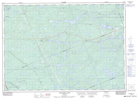
041H16 Noganosh Lake Canada topo map, 1:50,000 scale
041H16 Noganosh Lake NRCAN topographic map.
Includes UTM and GPS geographic coordinates (latitude and longitude). This 50k scale map is suitable for hiking, camping, and exploring, or you could frame it as a wall map.
Printed on-demand using high resolution, on heavy weight and acid free paper, or as an upgrade on a variety of synthetic materials.
Topos available on paper, Waterproof, Poly, or Tyvek. Usually shipping rolled, unless combined with other folded maps in one order.
- Product Number: NRCAN-041H16
- Parent Topo: TOPO-041H
- Map ID also known as: 041H16, 41H16
- Unfolded Size: Approximately 26" high by 36" wide
- Weight (paper map): ca. 55 grams
- Map Type: POD NRCAN Topographic Map
- Map Scale: 1:50,000
- Geographical region: Ontario, Canada
Neighboring Maps:
All neighboring Canadian topo maps are available for sale online at 1:50,000 scale.
Purchase the smaller scale map covering this area: Topo-041H
Spatial coverage:
Topo map sheet 041H16 Noganosh Lake covers the following places:
- Buchus Bay - Clear Bay - Deep Bay - Deep Bay - Hole in the Wall - Long Bay - Noggart's Bay - Pigeon Bay - Ponford's Bay - Sandy Bay - Shanty Bay - Smith Bay - Stumpy Bay - Mortons Point - The Elbow - Deadmans Narrows - Ess Narrows - Lost Channel - Main Channel - S Narrows - The Outlet - Horseshoe Falls - Mountain Chute - Blair - Brown - Burton - Hardy - McConkey - McKenzie - Mowat - Parry Sound - Wallbridge - Wilson - French River Indian Reserve 13 - Magnetawan Indian Reserve 1 - Réserve indienne French River 13 - Réserve indienne Magnetawan 1 - Burnt Island - Burnt Island - Cantin Island - Caribou Island - Carve Island - Cincinnati Island - Comfort Island - Deadmans Island - Effrick Island - High Rock Island - Little Lookout Island - Long Island - Lookout Island - Miramichi Island - Sandy Hook - Tuffy's Island - Upsilanti Island - Wade's Island - Arthur Lake - Ball Lake - Balsam Lake - Bass Lake - Big Caribou Lake - Boodis Lake - Burnt Lake - Caribou Lake - Circle Lake - Clear Lake - Cole Lake - Cookery Lake - Council Lake - Courtney Lake - Cross Lake - Crow Lake - Deep Lake - Dollars Lake - Duck Lake - Duck Lake - Dutton Lake - Etta Lake - Finney Lake - Foreshew Lake - Fox Lake - Hatch Lake - Howe's Lake - Index Lake - Irwin Lake - Island Lake - Island Lake - John Lake - Kaiser Lake - Kawigamog Lake - Kawigamog Lake - Kelsie Lake - Lagg Lake - Last Lake - Levesque Lake - Little Balsam Lake - Little Caribou Lake - Little Etta Lake - Little John Lake - Little Long Lake - Little Wolf Lake - Long Lake - Loon Lake - Loon Lake - Loon Lake - Lost Lake - Lower Courtney Lake - Memesagamesing Lake - Middle Shanty Bay Lake - Minnowtrap Lake - Moose Lake - Mouse Lake - Mud Lake - Mud Lake - Muskrat Lake - Noganosh Lake - Oldcamp Lake - Otter Lake - Partridge Lake - Pine Lake - Portage Lake - Portage Lake - Rabbit Lake - Rat Lake - Round Lake - Shanty Bay Lakes - Sinclair Lake - Smith Lake - Smoky Lake - Spikehorn Lake - Squaw Lake - Sunny Lake - Swan Lake - The Top Lake - Toad Lake - Trout Lake - Waldrons Lake - Wauquimakog Lake - Weiler Lake - Windy Lake - Wishbone Lake - Wolf Lake - Wolf Lake - Wolf Lake - Kidd's Landing - Hagerman - Magnetawan - Whitestone - Blair Township Nature Reserve Wilderness Area - French River Provincial Park - Grundy Lake Provincial Park - Island Lake Forest and Barrens Conservation Reserve - Magnetawan River Provincial Park - Mowat Township Hemlock Forest Conservation Reserve - Noganosh Lake Provincial Park - Northern McConkey Conservation Reserve - Pakeshkag River Forest Conservation Reserve - Swan Lake Conservation Reserve - Bruce's Rapids - Horserace Rapids - Mosquito Rapids - Mud Lake Rapids - Sand Rapids - Stovepipe Rapids - The Big Eddy - Back Snye - Blaney Creek - Caribou Creek - Caribou River - Courtney Creek - Cramadog Creek - Dog Creek - Farm Creek - Fivemile River - Key River - Little Key River - Loon Lake Creek - Magnetawan River - Mud Creek - Pakeshkag River - Pickerel River - Smoky Creek - Still River - Sturdies Creek - Windy Creek - Wolf River - Dead Hole - Moby Dick - Drocourt - Fleming's Landing - Lost Channel - Mowat - Still River - The Depot


