
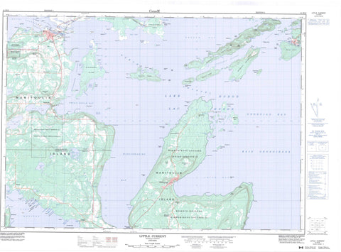
041H13 Little Current Canada topo map, 1:50,000 scale
041H13 Little Current NRCAN topographic map.
Includes UTM and GPS geographic coordinates (latitude and longitude). This 50k scale map is suitable for hiking, camping, and exploring, or you could frame it as a wall map.
Printed on-demand using high resolution, on heavy weight and acid free paper, or as an upgrade on a variety of synthetic materials.
Topos available on paper, Waterproof, Poly, or Tyvek. Usually shipping rolled, unless combined with other folded maps in one order.
- Product Number: NRCAN-041H13
- Parent Topo: TOPO-041H
- Map ID also known as: 041H13, 41H13
- Unfolded Size: Approximately 26" high by 36" wide
- Weight (paper map): ca. 55 grams
- Map Type: POD NRCAN Topographic Map
- Map Scale: 1:50,000
- Geographical region: Ontario, Canada
Neighboring Maps:
All neighboring Canadian topo maps are available for sale online at 1:50,000 scale.
Purchase the smaller scale map covering this area: Topo-041H
Spatial coverage:
Topo map sheet 041H13 Little Current covers the following places:
- Baie Georgienne - Bathouse Bay - Beaver Island Harbour - Bowell Cove - Boyle Cove - Bragmore Bay - Browning Cove - Buzwales Cove - Cameron Cove - Camp Cove - Cape Horn Bay - Chapleau Cove - Covered Portage Cove - Dawes Bay - Dick's Bay - Fishing Island Cove - Frazer Bay - Georgian Bay - Giwshkwebi Bay - High Beach Cove - Killarney Bay - Killarney Harbour - Little River - Mackay's Bay - Mallard Cove - Manitowaning Bay - Melvin Bight - Mosquito Bay - Plummer Cove - Portage Cove - Powderhouse Bay - Powell Cove - Sandy Cove - Shallow Bay - Shearpin Bay - Sheguiandah Bay - Shirley's Bay - Shoal Bight - Silver Bay - Smith Bay - Snug Harbour - Surecatch Bay - Tilson's Bay - Turner Cove - Turtle Creek Bay - Watson Bay - Wee Point Bay - White Cove - White's Cove - High Beach - Ashiganshing Point - Badgeley Point - Bird Point - Bold Point - Bragmore Point - Cape Horn Point - Cape Smith - Caron Point - Castigan Point - Chapleau Point - Dinner Point - East Point - English Point - Evans Point - Fish Point - Flat Point - Frost Point - Gibbons Point - Gibson Point - Gow Point - Griffiths Point - Indian Dock Point - Kanigandibe Point - Le Haye Point - Leech Point - Limestone Point - Lobster Point - Lone Star Point - Long Point - Long Point - Mackay Point - Mackay's Point - Magazine Point - Maple Rock Point - Mary Point - Maxwell Point - Mayes Point - Meshkodeyang Point - Miller Point - Monk Point - Nadeau Point - O'Meara Point - Oxley Point - Paul's Point - Phipps Point - Prairie Point - Sagamaw Point - Sandy Point - Shoal Island Spit - Shutin Point - Sims Point - Skull Point - South Point - Southeast Point - Stanley Point - Stony Point - Sturgeon Point - Ten Mile Point - The Gut Dock - Thompson Point - Underhill Point - Watson Point - Wee Point - Wharton Point - Hole in the Wall - Killarney Channel - Lansdowne Channel - Little Current - North Channel - North Channel - Pine Island Channel - Strawberry Channel - The Narrows - Baudin Bluff - Bayfield Bluff - Clay Cliff - East Red Cliff - West Red Cliff - High Falls - Assiginack - Bidwell - Howland - Manitoulin - Rutherford - Sandfield - Sheguiandah - Réserve indienne Sheguiandah 24 - Réserve indienne Sucker Creek 23 - Réserve indienne Wikwemikong Unceded 26 - Sheguiandah 24 - Sheguiandah Indian Reserve 24 - Sucker Creek 23 - Sucker Creek Indian Reserve 23 - Wikwemikong Unceded Indian Reserve 26 - Anthony Island - Badgeley Island - Beauty Island - Beaver Island - Big Burnt Island - Big Gooseberry Island - Browning Island - Centre Island - Creak Island - Deepwater Island - Double Island - Double Islands - Dufferin Island - East Mary Island - East Mound - Elm Island - Fishing Island - Garden Island - George Island - Giwshkwebi Island - Goat Island - Gooseberry Island - Great Cloche Island - Great La Cloche Island - Gull Island - Harris Island - Heywood Island - Hog Island - King William Island - Kokanongwi Island - Lisgar Island - Little Cloche Island - Little Gooseberry Island - Little Island - Little Island - Little La Cloche Island - Lobster Island - Loon Island - Low Island - Maltas Island - Manitoulin Island - McKenzie Island - Narrow Island - Northwest Burnt Island - One Mile Island - Partridge Island - Partridge Island - Patten Island - Pender Islets - Picnic Island - Pine Island - Rabbit Island - Seagull Island - Sheep Island - Shibabiyag - Shoal Island - Snake Island - Spider Island - Strawberry Island - The Nest - Tin Can Island - Tree's Island - Twin Islands - West Mary Island - West Mound - William Island - Badgeley Lake - Bass Lake - Devils Bay Lake - East Lily Lake - Lac Huron - Lake Huron - Lake Manitou - Manitou Lake - North Pine Lake - Perch Lake - Pike Lake - Pine Lake - Turtle Lake - Fisher Harbour - Mocassets Landing - Ayekwadinak Hill - Columbus Mountain - Lions Head - Lions Rump - McLeans Mountain - Murray Hill - Sheguiandah Hill - The Spur - Wikwemikong Hill - Assiginack - Carnarvon - Central Manitoulin - Howland - Rutherford and George Island - Sandfield - Francis Brook - Goat Island Channel - Kaboni Creek - Norton's Creek - Sanswe Creek - Springer Brook - Sucker Creek - Rat Portage - Ann Long Bank - Azov Ledges - Badgeley Rocks - Bayfield Reef - Bayfield Rock - Beaver Island Bank - Bernard Rock - Boat Rock - Boulton Reef - Burnt Island Bank - Campbell Rock - Caron Reef - Centre Island Bank - Double Island Ledges - Doyle Rock - Five Fathom Patch - Frank Ledge - Garden Island Bank - George Rock - Gibbons Bank - Goldhunter Rock - Gow Shoal - Gull Roost - Heywood Rock - Ironsides Rock - John Ledge - Kokanongwi Shingle - Langevin Rock - Leech Reef - Linter Rock - Loon Island Reef - McGregor Bank - Middle Bank - Nobles Bank - Partridge Island Rocks - Pelkie Rock - Petley Rock - Phipps Point Shoal - Powell Cove Bank - Quartz Rock - Rabbit Island Rock - Red Cliff Flat - Richards Reef - Sandy Cove Ledge - Six Fathom Patch - Skull Point Reef - Split Rock - Steamer Reef - Ten Mile Shoal - Watts Rock - Killarney - Northeastern Manitoulin and the Islands - Northeastern Manitoulin and the Islands - Bidwell - Buzwah - Dinner Point Depot - Eads Bush - Killarney - Little Current - Maiangowi Settlement - Sheguiandah - Turner - Vanzant's Landing - Wabozominissing - Wikwemikong


