
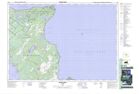
041H03 Dyer s Bay Canada topo map, 1:50,000 scale
041H03 Dyer s Bay NRCAN topographic map.
Includes UTM and GPS geographic coordinates (latitude and longitude). This 50k scale map is suitable for hiking, camping, and exploring, or you could frame it as a wall map.
Printed on-demand using high resolution, on heavy weight and acid free paper, or as an upgrade on a variety of synthetic materials.
Topos available on paper, Waterproof, Poly, or Tyvek. Usually shipping rolled, unless combined with other folded maps in one order.
- Product Number: NRCAN-041H03
- Parent Topo: TOPO-041H
- Map ID also known as: 041H03, 41H3, 41H03
- Unfolded Size: Approximately 26" high by 36" wide
- Weight (paper map): ca. 55 grams
- Map Type: POD NRCAN Topographic Map
- Map Scale: 1:50,000
- Geographical region: Ontario, Canada
Neighboring Maps:
All neighboring Canadian topo maps are available for sale online at 1:50,000 scale.
Purchase the smaller scale map covering this area: Topo-041H
Spatial coverage:
Topo map sheet 041H03 Dyer s Bay covers the following places:
- Baie Georgienne - Bradley Harbour - Dyer Bay - Dyer's Bay - French Bay - French Harbour - Georgian Bay - Isthmus Bay - Larsen Cove - Little Pine Tree Harbour - McKay's Harbour - Pine Tree Harbour - Pleasant Bay - Pleasant Harbour - Rocky Bay - Whippoorwill Bay - Wingfield Basin - Bruce Peninsula - Cabot Head - Cape Chin - Cave Point - Gun Point - Juno Point - Lighthouse Point - Lionhead - Lion's Head - Lion's Head Point - Pleasant Point - Scotch Thistle Point - Sibert Point - Silversides Point - Smokey Head - Smoky Head - Wingfield Point - South Bluff - West Bluff - Bruce - Eastnor - Lindsay - St. Edmunds - Swan Lake Drain - Cape Croker Hunting Ground 60B - Cape Croker Hunting Ground Indian Reserve 60B - Réserve indienne Cape Croker Hunting Ground 60B - Réserve indienne Saugeen Hunting Grounds 60A - Saugeen and Cape Croker Fishing Islands 1 - Saugeen Hunting Grounds Indian Reserve 60A - Franklin Island - Pleasant Isle - Zinkan Island - Ague Lake - Bartley Lake - Britain Lake - Clear Lake - Conley Lake - Crane Lake - Emmett Lake - George Lake - Gillies Lake - Ira Lake - Lac Huron - Lake Huron - Lower Andrew Lake - Lymburner Lake - Marley Lake - Miller Lake - Moore Lake - Otter Lake - Quenlin Lake - Shouldice Lake - Twin Marsh Lakes - Umbrella Lake - Upper Andrew Lake - Warder Lake - Boulder Bluff - Middle Bluff - The Forty Hills - White Bluff - Bruce - Eastnor - Lindsay - Northern Bruce Peninsula - St. Edmunds - Bruce Peninsula National Park of Canada - Cabot Head Provincial Nature Reserve - Cyprus Lake Provincial Park - Ira Lake Provincial Nature Reserve - Johnston Harbour-Pine Tree Point Provincial Nature Reserve - Lions Head Provincial Nature Reserve - Lion's Head Provincial Nature Reserve - Parc national du Canada de la Péninsule-Bruce - Smokey Head/White Bluff Provincial Nature Reserve - Brinkman's Creek - Chin Creek - Crane River - Sadler Creek - Sideroad Creek - Spring Creek - Stokes River - Willow Creek - Darling Reef - Eight Fathom Patch - Jackson Shoal - Loaf Rock - Surprise Shoal - Brinkman Corners - Brinkmans Corners - Brinkman's Corners - Cape Chin - Cape Chin North - Cape Chin South - Clarke's Corners - Dyer Bay - Dyer's Bay - Gillies Lake - McVicar - Miller Lake - Miller Lake East - Miller Lake West - Monument Corners - Stokes Bay - Big Marsh - Horseshoe Marsh - Shingle Marsh


