
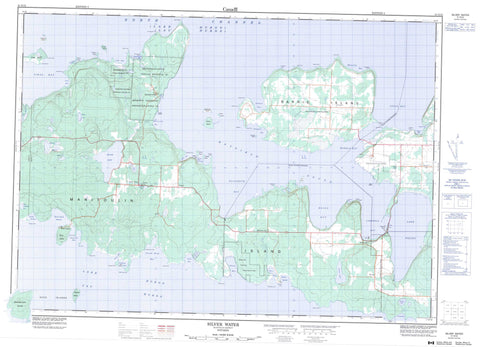
041G15 Silver Water Canada topo map, 1:50,000 scale
041G15 Silver Water NRCAN topographic map.
Includes UTM and GPS geographic coordinates (latitude and longitude). This 50k scale map is suitable for hiking, camping, and exploring, or you could frame it as a wall map.
Printed on-demand using high resolution, on heavy weight and acid free paper, or as an upgrade on a variety of synthetic materials.
Topos available on paper, Waterproof, Poly, or Tyvek. Usually shipping rolled, unless combined with other folded maps in one order.
- Product Number: NRCAN-041G15
- Parent Topo: TOPO-041G
- Map ID also known as: 041G15, 41G15
- Unfolded Size: Approximately 26" high by 36" wide
- Weight (paper map): ca. 55 grams
- Map Type: POD NRCAN Topographic Map
- Map Scale: 1:50,000
- Geographical region: Ontario, Canada
Neighboring Maps:
All neighboring Canadian topo maps are available for sale online at 1:50,000 scale.
Purchase the smaller scale map covering this area: Topo-041G
Spatial coverage:
Topo map sheet 041G15 Silver Water covers the following places:
- Battery Bluff Anchorage - Bayfield Sound - Blackstock Bay - Boat Harbour - Burns Harbour - Burnt Island Harbour - Campbell Bay - Carroll Wood Bay - Christina Bay - Cole Bay - Comfort Cove - Cook Bay - Cooks Bay - Creasor Bight - Cyril Cove - East Belanger Bay - Edward Bight - Elizabeth Bay - Fisher Bay - Fréchette Bay - Hartney Cove - Helen Bay - Hensley Bay - Julia Bay - Mac's Bay - Misery Bay - Morrisville Bay - Murphy Harbour - Nancy Bay - Portage Bay - Rickley Harbour - Rozels Bay - Salmon Bay - Sand Bay - Shigniconing Bay - Smith Bay - Sturgeon Bay - Vidal Bay - Walkhouse Bay - Arthur Point - Beer Point - Black Point - Blackstock Point - Botterell Point - Cape Robert - Cape Roberts - Creighton Point - Cuningham Point - Cunningham Point - Cyril Cove Point - Deacon Point - Deadman's Point - Dingy Point - Eaton Point - Edna Point - Elizabeth Point - Fishery Point - Fréchette Point - Gauthier Point - Goose Point - Green Point - Harold Point - Haydens Point - Horace Point - Indian Point - Ivan Point - Julia Point - Macaulay Spit - Misery Point - Murphy Point - Osborn Point - Portage Point - Portage Point Spit - Queen Point - Queens Point - Rickley Point - Shoal Point - Suicide Point - Walkhouse Point - North Channel - Battery Bluff - Scotts Bluff - Barrie Island - Burpee - Dawson - Gordon - Manitoulin - Mills - Robinson - Cockburn Island Indian Reserve 19A - Réserve indienne Cockburn Island 19A - Réserve indienne Sheshegwaning 20 - Réserve indienne Zhiibaahaasing 19A - Sheshegwaning 20 - Sheshegwaning Indian Reserve 20 - Zhiibaahaasing 19A - Zhiibaahaasing Indian Reserve 19A - Barrie Island - Bayard Island - Burnt Island - Charlie Island - Crescent Island - Duck Islands - Fanny Island - Gertrude Island - Griffith Island - Henry Island - Inner Duck Island - Jacks Island - Lapthorn Island - Manitoulin Island - Masson Island - Morris Island - Ned Island - Round Island - Skin Island - Stanley Island - Stony Island - Sturgeon Island - Thibault Island - Twilight Isle - Vidal Island - Western Duck Island - Beaver Meadow Lakes - Kemp Lake - Lake Huron - Lake Wolsey - Little Huron Lake - Lorne Lake - Mac's Lake - Maple Lake - Max Lake - Nineteen Lake - Portage Lake - Shaky Lake - Silver Lake - Wolsey Lake - Indian Hill - Nineteen Hill - Barrie Island - Burpee - Burpee and Mills - Gordon - Howland - Mac's Bay Conservation Reserve - Misery Bay Provincial Nature Reserve - Maple Creek - Silver Creek - Bayard Reef - Buller Reef - Frechette Bank - Gaspesia Shoal - Henry Island Sandbank - Henry Patch - Heron Patch - Horace Point Bank - Jubilee Shoal - Methuen Reef - Morrell Reef - Rudyard Reef - Saunders Reef - Seaman Reef - Stafford Rock - Taylor Reef - Thibault Shoal - Northeastern Manitoulin and the Islands - Northeastern Manitoulin and the Islands - Barrie Island - Burnt Island - Burpee - Elizabeth Bay - Evansville - Fernlee - Foxey - Morrisville - Sheshegwaning - Silver Water


