
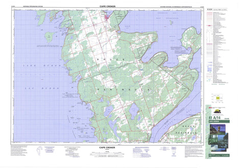
041A14 Cape Croker Canada topo map, 1:50,000 scale
041A14 Cape Croker NRCAN topographic map.
Includes UTM and GPS geographic coordinates (latitude and longitude). This 50k scale map is suitable for hiking, camping, and exploring, or you could frame it as a wall map.
Printed on-demand using high resolution, on heavy weight and acid free paper, or as an upgrade on a variety of synthetic materials.
Topos available on paper, Waterproof, Poly, or Tyvek. Usually shipping rolled, unless combined with other folded maps in one order.
- Product Number: NRCAN-041A14
- Parent Topo: TOPO-041A
- Map ID also known as: 041A14, 41A14
- Unfolded Size: Approximately 26" high by 36" wide
- Weight (paper map): ca. 55 grams
- Map Type: POD NRCAN Topographic Map
- Map Scale: 1:50,000
- Geographical region: Ontario, Canada
Neighboring Maps:
All neighboring Canadian topo maps are available for sale online at 1:50,000 scale.
Purchase the smaller scale map covering this area: Topo-041A
Spatial coverage:
Topo map sheet 041A14 Cape Croker covers the following places:
- Baie Georgienne - Barrow Bay - Boat Harbour - Colpoy Bay - Colpoys Bay - Colpoy's Bay - Cove of Cork Bay - Crab Cove - Gauley Bay - Georgian Bay - Gravelly Bay - Greenough Harbour - Hope Bay - Howdenvale Bay - Irish Harbour - Isthmus Bay - Jackson Cove - Jackson's Cove - Lionhead Harbour - Lion's Head Harbour - Little Pike Bay - Little Red Bay - Look About Bay - MacGregor Harbour - Melville Sound - Myles Bay - North Bay - Pike Bay - Purgatory Cove - Red Bay - Rush Cove - Shoal Cove - Simon Bay - Stokes Bay - Sydney Bay - Whiskey Harbour - Mallory Beach - Bartley Point - Benjamin's Point - Bruce Peninsula - Cape Dundas - Cape Paulett - Ferguson Point - Gravelly Point - Greenough Point - Gun Point - Harbour Point - Indian Point - Kings Point - Little Pike Point - McMaster Point - Montresor Point - Partridge Point - Petrel Point - Pike Point - Pine Tree Point - Prairie Point - Purgatory Point - Reid Point - Rocky Point - Shute Point - Simon Point - St. Jean Point - Stony Point - Geeshkaupikauhnssing Cliff - Jones Bluff - Kings Point Bluff - Village Cliff - Sydney Bay Bluff - Albemarle - Amabel - Bruce - Eastnor - Keppel - Lindsay - Angle Ditch - Swan Lake Drain - Cape Croker Indian Reserve 27 - Neyaashiinigmiing - Neyaashiinigmiing Indian Reserve 27 - Réserve indienne Cape Croker 27 - Réserve indienne Neyaashiinigmiing 27 - Réserve indienne Saugeen and Cape Croker Fishing Islands 1 - Saugeen and Cape Croker Fishing Islands Indian Reserve 1 - Argyle Islands - Barrier Island - Basswood Island - Beament Island - Burke Island - Cavalier Island - Dane Island - Deadman's Island - Evelyn Island - Fishing Islands - Garden Island - Ghegheto Island - Golden Island - Knife Islands - Kolfage Island - Ladder Islands - Little Haystack Island - Lyal Island - Main Station Island - McCallum Island - North Star Island - Old Woman Island - Parker Island - Rush Island - Saxon Island - Sunset Island - Tamarack Island - Tyson Island - Warren Island - Beattie Lake - Berford Lake - Big Mud Lake - Charles Lake - Gleason Lake - Hodgins Lake - Isaac Lake - Lac Huron - Lake Charles - Lake Huron - Little Lake - Little Lake - Little Mud Lake - Lucky Lake - Mud Lake - North Hodgins Lake - Patterson Lake - Rowes Lake - Sky Lake - West Little Lake - Bull's Landing - Astrop's Hill - Bannister's Hill - Coveney's Hill - Malcolm Bluff - Skinner Bluff - Skinner's Bluff - Bruce - Grey - Albemarle - Amabel - Derby - Eastnor - Georgian Bluffs - Keppel - Lindsay - Northern Bruce Peninsula - Sarawak - St. Edmunds - Black Creek Provincial Park - Hope Bay Forest Provincial Nature Reserve - Lions Head Provincial Nature Reserve - Albemarle Brook - Black Creek - Colpoy's Creek - Gleason Brook - Judges Creek - Old Woman River - Old Woman's River - Rankin River - Stokes River - Sucker Creek - Barrett Reef - Chimney Reefs - Cornet Ground - Corsair Reef - Corsdu Reef - Drake Shoal - Frolic Reef - Greenough Bank - Gundersen Shoal - Harrison Shoal - Hattie Rock - Lamorandiere Bank - Lincoln Shoal - Lyal Reef - Mad Reef - Milton Bank - Murton Reef - Port Elgin Shoal - Ripple Reef - Saturn Rock - Scout Reef - Seashell Rock - Wanderer Shoal - Wells Shoal - South Bruce Peninsula - Adamsville - Barrow Bay - Cape Croker - Centreville - Clay Hills - Colpoy Bay - Colpoys Bay - Colpoy's Bay - Edenhurst - Ferndale - Halfway Point - Hope Bay - Hopeness - Howdenvale - Lake Charles - Lion's Head - Little Port Elgin - Mar - McIver - Nayausheeng - Old Woman's River - Omeedjilawh Camp - Oxenden - Parker Landing - Pike Bay - Purple Valley - Red Bay - Spry - Stokes Bay - The Corra - Wiarton - Golden Valley - Eastnor Swamp - The Little Prairie - The Prairie - Lionhead


