
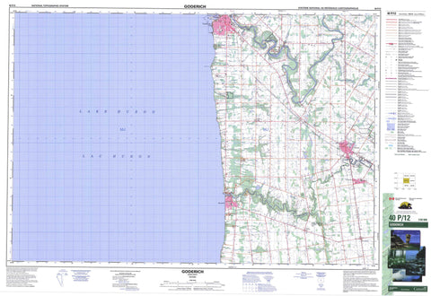
040P12 Goderich Canada topo map, 1:50,000 scale
040P12 Goderich NRCAN topographic map.
Includes UTM and GPS geographic coordinates (latitude and longitude). This 50k scale map is suitable for hiking, camping, and exploring, or you could frame it as a wall map.
Printed on-demand using high resolution, on heavy weight and acid free paper, or as an upgrade on a variety of synthetic materials.
Topos available on paper, Waterproof, Poly, or Tyvek. Usually shipping rolled, unless combined with other folded maps in one order.
- Product Number: NRCAN-040P12
- Parent Topo: TOPO-040P
- Map ID also known as: 040P12, 40P12
- Unfolded Size: Approximately 26" high by 36" wide
- Weight (paper map): ca. 55 grams
- Map Type: POD NRCAN Topographic Map
- Map Scale: 1:50,000
- Geographical region: Ontario, Canada
Neighboring Maps:
All neighboring Canadian topo maps are available for sale online at 1:50,000 scale.
Purchase the smaller scale map covering this area: Topo-040P
Spatial coverage:
Topo map sheet 040P12 Goderich covers the following places:
- Blacks Point - Colborne - Goderich - Hullett - Huron - Stanley - Tuckersmith - Layton Drain - Medd Drain - Indian Island - Ship Island - Lac Huron - Lake Huron - Tricks Pond - Huron - Ashfield - Ashfield-Colborne-Wawanosh - Central Huron - Colborne - Goderich - Grey - Hay - Hullett - Hullett - McKillop - Stanley - Tuckersmith - West Wawanosh - Morris Tract Provincial Nature Reserve - Bannockburn River - Bayfield River - Blyth Brook - Bridgewater Creek - Cemetery Creek - Gully Creek - Hopkins Creek - Maitland River - Naftel's Creek - Sharp Creek - Sharpes Creek - South Maitland River - Tricks Creek - Bluewater - Goderich - Huron East - Bayfield - Benmiller - Blue Water Beach - Brucefield - Clinton - Holmesville - McGaw - Porter Hill - Porter's Hill - Summerhill - Vanastra - Varna - Witmer


