
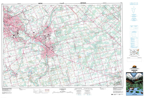
040P08 Cambridge Canada topo map, 1:50,000 scale
040P08 Cambridge NRCAN topographic map.
Includes UTM and GPS geographic coordinates (latitude and longitude). This 50k scale map is suitable for hiking, camping, and exploring, or you could frame it as a wall map.
Printed on-demand using high resolution, on heavy weight and acid free paper, or as an upgrade on a variety of synthetic materials.
Topos available on paper, Waterproof, Poly, or Tyvek. Usually shipping rolled, unless combined with other folded maps in one order.
- Product Number: NRCAN-040P08
- Parent Topo: TOPO-040P
- Map ID also known as: 040P08, 40P8, 40P08
- Unfolded Size: Approximately 26" high by 36" wide
- Weight (paper map): ca. 55 grams
- Map Type: POD NRCAN Topographic Map
- Map Scale: 1:50,000
- Geographical region: Ontario, Canada
Neighboring Maps:
All neighboring Canadian topo maps are available for sale online at 1:50,000 scale.
Purchase the smaller scale map covering this area: Topo-040P
Spatial coverage:
Topo map sheet 040P08 Cambridge covers the following places:
- McCormick Point - Berlin - Brant - Brant-on-the-Grand - Cambridge - Guelph - Hamilton - Kitchener - Waterloo - Niagara Escarpment - Ancaster - Beverly - Blenheim - Brant - Dumfries - East Flamborough - Guelph - Nassagaweya - North Dumfries - Oxford - Puslinch - South Dumfries - Waterloo - Waterloo - Wellington - Wentworth - West Flamborough - Big Island - Musselshell Island - St. Helen Island - Summer Island - Bannister Lake - Barrie Lake - Barrie's Lake - Beake Pond - Blue Springs Pond - Christie Reservoir - Cottrell Lake - Cowan's Lake - Deans Lake - Despond Lakes - Elliott's Lake - Emerald Lake - Grass Lake - Gulliver's Lake - Hillside Lake - Jedburgh Pond - Little Lake - Little Turnbull Lake - McCrone Lake - McCrone's Lakes - Mill Pond - Millers Lake - Moore Pond - Mountsberg Reservoir - Orrs Lake - Orr's Lake - Pinehurst Lake - Puslinch Lake - Reid's Lake - Spottiswood Lakes - Sprague's Lake - Taylor Lake - Turnbull Lake - Valens Reservoir - Victoria Park Lake - Watson Pond - Willow Lake - Wrigley Lake - Wrigley's Lake - Hill Sixty - Pinnacle Hill - Shantz Hill - Brant - Halton - Hamilton-Wentworth - Oxford - Waterloo - Wellington - Wentworth - Ancaster - Beverly - Binbrook - Blandford-Blenheim - Blenheim - Brantford - Burford - Dumfries - Dumfries - Eramosa - Glanbrook - Glanford - Guelph - Guelph/Eramosa - Nassagaweya - Nichol - North Dumfries - Oakland - Onondaga - Pilkington - Puslinch - Puslinch - South Dumfries - Waterloo - Waterloo - Woolwich - Bannister Lake Complex Conservation Area - Beverly Swamp Conservation Area - Chicopee Hills Conservation Area - Christie Reservoir Conservation Area - Crooks Hollow Conservation Area - F.W.R. Dickson Conservation Area - Lieu historique national du Canada Woodside - Mountsberg Conservation Area - Puslinch Lake Conservation Area - Shades Mills Conservation Area - Woodside National Historic Site of Canada - Aberfoyle Creek - Alder Creek - Balzer Creek - Barlow Creek - Bechtel Creek - Big Creek - Blair Creek - Bowman Creek - Bronte Creek - Cedar Creek - Charlie Creek - Eden Creek - Ellis Creek - Fairchild Creek - Fletcher Creek - Galt Creek - Grand River - Hopewell Creek - Idlewood Creek - Irish Creek - Kolb Creek - Laurel Creek - Melitzer Creek - Mill Creek - Moffatt Creek - Moffatt's Creek - Montgomery Creek - Mountsberg Creek - Nith River - Schneider Creek - Shoemaker Creek - Speed River - Spencer Creek - Spencer Creek - Strasburg Creek - West Spencer Creek - Milton - Aberfoyle - Aikensville - Alpine Village - Ancaster - Ayr - Babenoch - Badenoch - Barber's Beach - Blair - Branchton - Breezy's Corners - Breslau - Bridgeport - Brock Gardens - Bruces - Centreville - Christies Corner - Christies Corners - Clyde - Country Hills - Crieff - Doon - Downeys - East Preston - Fisher Mills - Flamboro West - Flamborough - Forest Hills - Freelton - Freeport - Galt - German Mills - Glen Morris - Glenchristie - Glenwood Heights - Greenfield - Guelph Junction - Hagey - Hayesland - Heritage Park - Hespeler - Idylwild - Killean - Killean Station - Kirkwall - Kossuth - Laurentian Hills - Little Lake - Littles Corners - Morriston - Mountsberg - Orkney - Orrs Lake - Orr's Lake - Parkway - Peters Corners - Pinehurst Park - Preston - Puslinch - Reid's Mill - Reidsville - Rockton - Rockway - Rosemount - Rosendale - Roseville - Sheffield - Shep's Subdivision - Stanley Park - Strabane - Strasburg - Troy - Valens - Victoria Hills - West Flamborough - Westover - Williamsburg - Wrigley Corners - Crook's Hollow - Dundas Valley - Badenoch Swamp - Beverly Swamp - Gilholm's Marsh - Moffat Swamp - Oliver's Marsh - Roseville Swamp - Sink-Hole Swamp


