
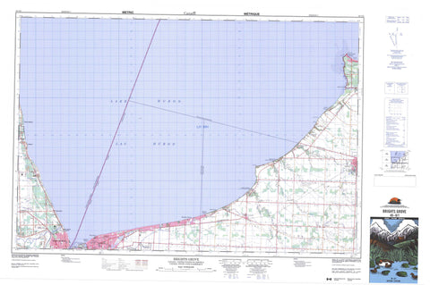
040O01 Brights Grove Canada topo map, 1:50,000 scale
040O01 Brights Grove NRCAN topographic map.
Includes UTM and GPS geographic coordinates (latitude and longitude). This 50k scale map is suitable for hiking, camping, and exploring, or you could frame it as a wall map.
Printed on-demand using high resolution, on heavy weight and acid free paper, or as an upgrade on a variety of synthetic materials.
Topos available on paper, Waterproof, Poly, or Tyvek. Usually shipping rolled, unless combined with other folded maps in one order.
- Product Number: NRCAN-040O01
- Parent Topo: TOPO-040O
- Map ID also known as: 040O01, 40O1, 40O01
- Unfolded Size: Approximately 26" high by 36" wide
- Weight (paper map): ca. 55 grams
- Map Type: POD NRCAN Topographic Map
- Map Scale: 1:50,000
- Geographical region: Ontario, Canada
Neighboring Maps:
All neighboring Canadian topo maps are available for sale online at 1:50,000 scale.
Purchase the smaller scale map covering this area: Topo-040O
Spatial coverage:
Topo map sheet 040O01 Brights Grove covers the following places:
- Ipperwash Beach - Blue Point - Cape Ipperwash - Cedar Point - Harris Point - Kettle Point - Point Edward - Lambton Shores - Sarnia - Sarnia-Clearwater - Bosanquet - Lambton - Plympton - Sarnia - Warwick - Cull Drain - Wawanosh Drain - Kettle Point 44 - Kettle Point Indian Reserve 44 - Réserve indienne Kettle Point 44 - Lac Huron - Lake Chipican - Lake Huron - Lambton - Plympton - Plympton - Warwick - Warwick - Ontario - Aberarder Creek - Bonnie Doon Creek - Cow Creek - Errol Creek - Hickory Creek - Highland Creek - Perch Creek - Perch Creek - Pulse Creek - Rivière Sainte-Claire - Shashawandah Creek - St. Clair River - Corsica Shoal - Harlem Shoal - Kettle Point Reef - Bosanquet - Clearwater - Plympton-Wyoming - Aberarder - Blackwell - Brights Grove - Camlachie - Cedar Point - Errol - Eton Court - Forest - Forest Hill - Glendale Beach - Gustin Grove - Highland Glen - Hillsborough Beach - Huron Heights - Ipperwash Beach - Kennedy Acres - Kettle Point - Miller - Oak Acres - Oakwood Corners - Perch - Uttoxeter - Valleyfield - Vyner - Wees Beach - Woodland - Woodrow Beach - Woodrowe Shores - Point Edward


