
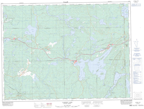
032D04 Larder Lake Canada topo map, 1:50,000 scale
032D04 Larder Lake NRCAN topographic map.
Includes UTM and GPS geographic coordinates (latitude and longitude). This 50k scale map is suitable for hiking, camping, and exploring, or you could frame it as a wall map.
Printed on-demand using high resolution, on heavy weight and acid free paper, or as an upgrade on a variety of synthetic materials.
Topos available on paper, Waterproof, Poly, or Tyvek. Usually shipping rolled, unless combined with other folded maps in one order.
- Product Number: NRCAN-032D04
- Parent Topo: TOPO-032D
- Map ID also known as: 032D04, 32D4, 32D04
- Unfolded Size: Approximately 26" high by 36" wide
- Weight (paper map): ca. 55 grams
- Map Type: POD NRCAN Topographic Map
- Map Scale: 1:50,000
- Geographical region: Ontario, Canada
Neighboring Maps:
All neighboring Canadian topo maps are available for sale online at 1:50,000 scale.
Purchase the smaller scale map covering this area: Topo-032D
Spatial coverage:
Topo map sheet 032D04 Larder Lake covers the following places:
- Dublin Bay - Fitzpatrick Bay - Hannigan Bay - Northeast Arm - Northwest Bay - Southwest Arm - Spoon Bay - Pearl Beach - Enright Point - Gold King Point - Indian Point - Lucky Boy Point - Tighe Point - Big Narrows - Little Narrows - The Narrows - Raven Falls - Arnold - Boston - Catharine - Dasserat - Dufay - Gauthier - Hearst - Katrine - Lebel - McElroy - McFadden - McGarry - McVittie - Morrisette - Ossian - Pacaud - Rattray - Skead - Timiskaming - Bernice Island - Big Pete Island - Island CC - Island U - Adamson Lake - Ava Lake - Barber Lake - Barnard Lake - Bear Lake - Beaver Lake - Beaverhouse Lake - Bidgood Pothole - Binney Lake - Blackwell Lake - Boundary Lakes - Coate Lake - Corset Lake - Cripple Lakes - Crosby Lake - Crystal Lake - Diamond Lake - Doig Lake - Estrangement Lake - Fork Lake - Fox Lake - Gardner Lake - Gem Lake - Glover Lake - Gold Lake - Grace Lake - Grassy Lake - Gull Lake - Hanson Lake - Heart Lake - Highwater Lake - Hines Lake - Howard Lake - Jordan Lake - Joyce Lake - Killarney Lake - Kinabik Lake - Labyrinth Lake - Lac à Bernard - Lac Buies - Lac Delaas - Lac des Îles - Lac des Morts - Lac du Serpent - Lac Germain - Lac Hauteville - Lac Hauteville - Lac Hébert - Lac Labyrinthe - Lac Labyrinthe - Lac Lemieux - Lac Marjorie - Lac Opwataongajing - Lac Raven - Lac Ross - Lac Wawagoshe - Lacs Boundary - Lacs de la Frontière - Larder Lake - Lemieux Lake - Link Lake - Little Larder Lake - Little Long Lake - Long Lake - Malone Lake - Marjorie Lake - McMurtry Lake - McTavish Lake - Misema Lake - Monocle Lake - Moosehead Lake - Mousseau Lake - Mud Lake - Mulven Lake - Nelson Lake - Nettie Lake - Pancake Lake - Rathwell Lake - Raven Lake - Rodensere Lake - Ross Lake - Sawdust Lake - Shaver Lake - Smith Lake - Sourdough Lake - Spectacle Lakes - Spring Lake - Tournene Lake - Turtle Lake - Victoria Lake - Ward Lake - Waterhen Lake - Wawagoshe Lake - Wilson Lake - York Lake - Colline Cheminis - Workman Hills - Gauthier - Larder Lake - McGarry - East Larder River Bedrock Conifer Conservation Reserve - Gem Lake Maple Bedrock Provincial Park - Larder River Waterway Provincial Park - McGarry Township Forest Conservation Reserve - South Grassy Lake Outwash Conservation Reserve - Alfie Creek - Bear Creek - Benson Creek - Black River - Boston Creek - Estrangement Creek - Kinabik Creek - Larder River - Little Misema River - Malone Creek - McElroy Creek - Milky Creek - Misema River - Mist Creek - Moosehead Creek - Morrisette Creek - Mousseau Creek - Pancake Creek - Rivière Laberge - Sharp Creek - Smith Creek - Spring Creek - Victoria Creek - Wawagoshe Creek - Kirkland Lake - Argonaut - Beaver Lake - Boston Creek - Cheminis - Crystal Beach - Dalby - Diamond Lake - Dobie - Kearns - King Kirkland - King Kirkland Station - Larder Lake - McNamara - Northlands Park - Rosegrove - Virginiatown - Chesterville


